IMAGES TAKEN NEAR TO
Dufton, APPLEBY-IN-WESTMORLAND, CA16 6DA
Introduction
This page details the photographs taken nearby to CA16 6DA by members of the Geograph project.
The Geograph project started in 2005 with the aim of publishing, organising and preserving representative images for every square kilometre of Great Britain, Ireland and the Isle of Man.

There are currently over 7.5m images from over14,400 individuals and you can help contribute to the project by visiting https://www.geograph.org.uk
Image Map
Images are licensed for reuse under creativecommons.org/licenses/by-sa/2.0
Notes
- Clicking on the map will re-center to the selected point.
- The higher the marker number, the further away the image location is from the centre of the postcode.
Image Listing (10 Images Found)
Images are licensed for reuse under creativecommons.org/licenses/by-sa/2.0
Image
Details
Distance
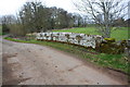
1
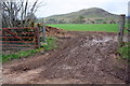
View through gateway towards Dufton Pike
Image: © Roger Templeman
Taken: 19 Mar 2019
0.14 miles
2
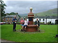
Dufton
Walkers resting on the village pump on Dufton Green. Dufton is a centre for visitors having a car park, toilets, shop/tearoom, youth hostel, accommodation and public house. Just as well as the village lies on the Pennine Way, Cumbrian Cycleway and the Pennine Bridleway
Image: © Carl Bendelow
Taken: 4 Aug 1998
0.17 miles
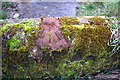
4
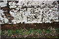
Benchmark on Church Bridge
Ordnance Survey cut mark benchmark described on the Bench Mark Database at www.bench-marks.org.uk/bm90771
Image: © Roger Templeman
Taken: 19 Mar 2019
0.18 miles
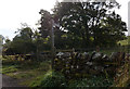
5
Church Bridge over Swindale Beck
There is an OS benchmark Image on the centre of the parapet
Image: © Roger Templeman
Taken: 19 Mar 2019
0.19 miles
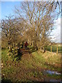
6

Eller Beck seen over SW parapet of Ellerbeck Bridge
There is an OS benchmark Image on top of the bridge parapet where the moss has been cleared
Image: © Roger Templeman
Taken: 19 Mar 2019
0.19 miles
7
Benchmark on Ellerbeck Bridge
Ordnance Survey rivet benchmark (with rivet missing) described on the Bench Mark Database at www.bench-marks.org.uk/bm105879
Image: © Roger Templeman
Taken: 19 Mar 2019
0.19 miles
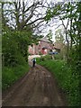
8
Old way near Dufton
An ancient way bounded by old trees which is the track from the village of Dufton to the isolated church of St Catherine which is sited about halfway between the villages of Dufton & Knock.
Image: © Christopher Hall
Taken: 2 Jan 2015
0.19 miles
9

Approaching St Catherine's Church
St Catherine's Church occupies an isolated position about halfway between the villages of Dufton and Knock. one of the ways of reaching it is by this field path.The present church is late 18th century replacing an earlier one of about 1293.
Image: © Christopher Hall
Taken: 2 Jan 2015
0.23 miles
10
Coatsike Farm, Dufton
From the Pennine Way
Image: © Dave Dunford
Taken: 28 May 2005
0.24 miles