IMAGES TAKEN NEAR TO
Dufton, APPLEBY-IN-WESTMORLAND, CA16 6BZ
Introduction
This page details the photographs taken nearby to CA16 6BZ by members of the Geograph project.
The Geograph project started in 2005 with the aim of publishing, organising and preserving representative images for every square kilometre of Great Britain, Ireland and the Isle of Man.

There are currently over 7.5m images from over14,400 individuals and you can help contribute to the project by visiting https://www.geograph.org.uk
Image Map
Images are licensed for reuse under creativecommons.org/licenses/by-sa/2.0
Notes
- Clicking on the map will re-center to the selected point.
- The higher the marker number, the further away the image location is from the centre of the postcode.
Image Listing (120 Images Found)
Images are licensed for reuse under creativecommons.org/licenses/by-sa/2.0
Image
Details
Distance
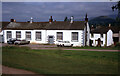
1

Town End houses
There is an OS benchmark Image on the near corner, road face, of the nearest house (original part)
Image: © Roger Templeman
Taken: 19 Mar 2019
0.00 miles
2

Benchmark on #1 Town End
Ordnance Survey cut mark benchmark described on the Bench Mark Database at www.bench-marks.org.uk/bm105875
Image: © Roger Templeman
Taken: 19 Mar 2019
0.01 miles
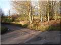
3
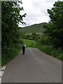
Leaving Dufton on the Pennine Way
Dufton Pike (Image) in the background.
Image: © Dave Dunford
Taken: 28 May 2005
0.01 miles
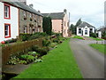
4
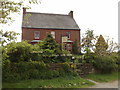
Dufton: Hall Croft
Formerly a B&B on the edge of the village.
Image: © Jonathan Hutchins
Taken: 23 May 2009
0.03 miles
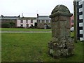
5
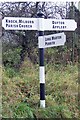
Old Direction Sign - Signpost north of Dufton
Ogee finial - 3 arms (restored); by the UC road, in parish of Dufton (Eden District), North edge of village by village sign.
Surveyed
Milestone Society National ID: WE_NY6825
Image: © Milestone Society
Taken: Unknown
0.03 miles
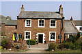
7
Dufton's old school
Dufton is an important staging post on the Pennine Way before or after the ascent of Cross Fell, the highest point in the Pennines.
Image: © David M Clark
Taken: 2 Apr 1971
0.05 miles
8
Old milk churn stand near Dufton
Sited at the junction between the roads to Mill Beck bridge (on the left) and Ellerbeck Bridge on the right is this stand which would have been used for milk churns awaiting collection when that collection method was in operation.
Image: © Christopher Hall
Taken: 2 Jan 2015
0.05 miles
9
A Corner of Dufton
Looking north west, just down from the Youth Hostel. The path from Brampton and Appleby comes in beside the pink house.
Image: © Chris Heaton
Taken: 7 Sep 2009
0.05 miles
10
Water supply on Dufton's Green
The Quaker-owned London Lead Company operated the local mines in the 1800s and installed piped water in the village. This was probably a public tap.
Image: © Christine Johnstone
Taken: 16 Feb 2017
0.05 miles