IMAGES TAKEN NEAR TO
Crackenthorpe, APPLEBY-IN-WESTMORLAND, CA16 6AE
Introduction
This page details the photographs taken nearby to CA16 6AE by members of the Geograph project.
The Geograph project started in 2005 with the aim of publishing, organising and preserving representative images for every square kilometre of Great Britain, Ireland and the Isle of Man.

There are currently over 7.5m images from over14,400 individuals and you can help contribute to the project by visiting https://www.geograph.org.uk
Image Map
Images are licensed for reuse under creativecommons.org/licenses/by-sa/2.0
Notes
- Clicking on the map will re-center to the selected point.
- The higher the marker number, the further away the image location is from the centre of the postcode.
Image Listing (17 Images Found)
Images are licensed for reuse under creativecommons.org/licenses/by-sa/2.0
Image
Details
Distance
1

Old Milestone by the A66, Crackenthorpe parish
Stone post (plate lost) by the A66, in parish of CRACKENTHORPE (EDEN District), 100m East of village junction, opposite Holme Lea, Northeast of Crackenthorpe Hall, was at Image; moved when route of A66 altered, on North side of road. Appleby plate, erected by the Brough & Eamont Bridge turnpike trust in the 19th century.
Inscription once read:-
: (APPLEBY / 2 MILES) : : (PENRITH / 11 MILES) :
Grade II listed.
List Entry Number: 1225905 https://historicengland.org.uk/listing/the-list/list-entry/1225905
Milestone Society National ID: WE_PRAP11.
Image: © C Smith / G Farrington
Taken: 18 Sep 2007
0.03 miles
2

Old Milestone with modern plate by the A66, south east of Crackenthorpe
Old Stone post with replacement plate by the A66, in parish of CRACKENTHORPE (EDEN District), 100m East of village junction, North of Holme Lea and North East of Crackenthorpe Hall. Was at Image but moved when route of A66 altered, on North side of road. Originally Appleby plate, erected by the Brough & Eamont Bridge turnpike trust in the 19th century. The modern plate was cast in alloy in 2020.
Inscription reads:- : APPLEBY / 2 MILES : : PENRITH 11 MILES : : BOWERBANK / PENRITH :
Listed.
Milestone Society National ID: WE_PRAP11R.
Image: © Terry Moore
Taken: 7 May 2020
0.03 miles
3
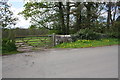
Track to Crackenthorpe Hall from old A66
Image: © Roger Templeman
Taken: 7 May 2015
0.05 miles
4
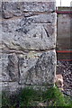
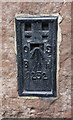
Benchmark on barn
Ordnance Survey cut mark benchmark described on the Bench Mark Database at http://www.bench-marks.org.uk/bm48384
Image: © Roger Templeman
Taken: 7 May 2015
0.12 miles
5

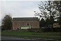
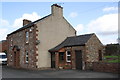
Barn at entrance to Crackenthorpe from A66
There is an OS benchmark Image on the near corner (left hand face) of the barn
Image: © Roger Templeman
Taken: 7 May 2015
0.12 miles
8

Turning for Crackenthorpe from the A66
Image: © Andrew Abbott
Taken: 15 May 2010
0.13 miles
9
Benchmark on 'Wayside'
Ordnance Survey flush bracket (serial number 1252) benchmark described on the Bench Mark Database at http://www.bench-marks.org.uk/bm2404
Image: © Roger Templeman
Taken: 7 May 2015
0.16 miles
10
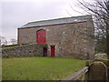
'Wayside', a former pub
There is an OS flush bracket benchmark Image on the first quoin up from ground on the house
Image: © Roger Templeman
Taken: 7 May 2015
0.16 miles