IMAGES TAKEN NEAR TO
Grange Avenue, MARYPORT, CA15 8RE
Introduction
This page details the photographs taken nearby to Grange Avenue, CA15 8RE by members of the Geograph project.
The Geograph project started in 2005 with the aim of publishing, organising and preserving representative images for every square kilometre of Great Britain, Ireland and the Isle of Man.

There are currently over 7.5m images from over14,400 individuals and you can help contribute to the project by visiting https://www.geograph.org.uk
Image Map
Images are licensed for reuse under creativecommons.org/licenses/by-sa/2.0
Notes
- Clicking on the map will re-center to the selected point.
- The higher the marker number, the further away the image location is from the centre of the postcode.
Image Listing (14 Images Found)
Images are licensed for reuse under creativecommons.org/licenses/by-sa/2.0
Image
Details
Distance
1
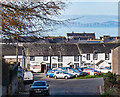
Former "Wheatsheaf Inn", Flimby - October 2017
Thought to be the white rendered building on the right in this view, the "Wheatsheaf Inn" first appears in Slater's Directory of 1848, but is probably much older. No record of closure has been found, but the Inn is marked on the 1960 OS Map.
Now a private dwelling with no public access.
Image: © The Carlisle Kid
Taken: 27 Oct 2017
0.06 miles
2

Flimby Church
A rather plain and sombre edifice.
Image: © Bob Jenkins
Taken: 9 Jan 2006
0.07 miles


6

Camping Sheep
Protection and ease of access for the farmer!
Image: © Bob Jenkins
Taken: 9 Jan 2006
0.10 miles
7
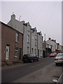
Ruby Hill Flimby
The three storey houses on this steep were built 1887 at the height of the coal mining era.
Image: © Bob Jenkins
Taken: 9 Jan 2006
0.14 miles

9
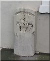
Old Milestone by the A596, Flimby, Maryport parish
Stone post by the A596, in parish of Maryport (Allerdale District), Flimby, against West face of building.
Defaced inscription once read:-
(Workington)
(4)
(Wigton)
(19)
Surveyed
Milestone Society National ID: CU_WGWO19
Image: © Milestone Society
Taken: Unknown
0.23 miles
10
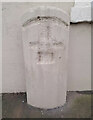
Old Milestone by the A596, Flimby, Maryport parish
Stone post by the A596, in parish of Maryport (Allerdale District), Flimby, against West face of building.
Defaced inscription once read:-
(Workington)
(4)
(Wigton)
(19)
Surveyed
Milestone Society National ID: CU_WGWO19
Image: © Barbara Todd
Taken: 2 Nov 2023
0.23 miles