IMAGES TAKEN NEAR TO
St. Helens Avenue, MARYPORT, CA15 8RB
Introduction
This page details the photographs taken nearby to St. Helens Avenue, CA15 8RB by members of the Geograph project.
The Geograph project started in 2005 with the aim of publishing, organising and preserving representative images for every square kilometre of Great Britain, Ireland and the Isle of Man.

There are currently over 7.5m images from over14,400 individuals and you can help contribute to the project by visiting https://www.geograph.org.uk
Image Map
Images are licensed for reuse under creativecommons.org/licenses/by-sa/2.0
Notes
- Clicking on the map will re-center to the selected point.
- The higher the marker number, the further away the image location is from the centre of the postcode.
Image Listing (30 Images Found)
Images are licensed for reuse under creativecommons.org/licenses/by-sa/2.0
Image
Details
Distance
2
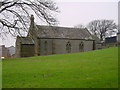
Flimby Church
A rather plain and sombre edifice.
Image: © Bob Jenkins
Taken: 9 Jan 2006
0.07 miles
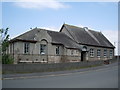
3
Former "Reading Room" and band hall, Flimby - October 2017
Currently disused with an uncertain future.
Image: © The Carlisle Kid
Taken: 27 Oct 2017
0.10 miles
4

Old chapel, Flimby
Not in use at the time of visit
Image: © Alexander P Kapp
Taken: 6 Jun 2007
0.10 miles
5
Camping Sheep
Protection and ease of access for the farmer!
Image: © Bob Jenkins
Taken: 9 Jan 2006
0.11 miles
6
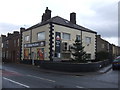
The Princess Royal, Flimby - June 2017
A modern pub, which appears to have closed circa 2007. It was State Managed from November 1918 until sold to John Smiths Brewing Group on 11 May 1973.
A photograph of the building in better days may be viewed: http://www.geog.port.ac.uk/webmap/thelakes/html/lgaz/lk14435.htm
Photograph is for record only - I have no connection with this business or any parties involved in the sale, and cannot advise on their products or services.
Image: © The Carlisle Kid
Taken: 19 Jun 2017
0.12 miles
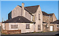
7
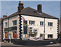
Former "Wheatsheaf Inn", Flimby - October 2017
Thought to be the white rendered building on the right in this view, the "Wheatsheaf Inn" first appears in Slater's Directory of 1848, but is probably much older. No record of closure has been found, but the Inn is marked on the 1960 OS Map.
Now a private dwelling with no public access.
Image: © The Carlisle Kid
Taken: 27 Oct 2017
0.14 miles
8
Flimby Village Store - June 2017
Situated on the corner of Station Road and Brook Street - the canvas sign reads "Flimby Pies Are Back!"
Photograph is for record only - I have no connection with this business and cannot advise on its products or services - or pies.
Image: © The Carlisle Kid
Taken: 19 Jun 2017
0.15 miles
10
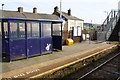
Waiting shelter and overbridge at Flimby Station
Image: © Roger Templeman
Taken: 9 Apr 2018
0.15 miles