IMAGES TAKEN NEAR TO
West Quay, MARYPORT, CA15 8BD
Introduction
This page details the photographs taken nearby to West Quay, CA15 8BD by members of the Geograph project.
The Geograph project started in 2005 with the aim of publishing, organising and preserving representative images for every square kilometre of Great Britain, Ireland and the Isle of Man.

There are currently over 7.5m images from over14,400 individuals and you can help contribute to the project by visiting https://www.geograph.org.uk
Image Map
Images are licensed for reuse under creativecommons.org/licenses/by-sa/2.0
Notes
- Clicking on the map will re-center to the selected point.
- The higher the marker number, the further away the image location is from the centre of the postcode.
Image Listing (239 Images Found)
Images are licensed for reuse under creativecommons.org/licenses/by-sa/2.0
Image
Details
Distance
1
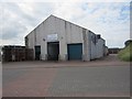
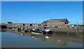
Maryport and Solway Fishing Co-operative
The premises of Maryport and Solway Fishing Co-operative.
Image: © Graham Robson
Taken: 14 Jul 2012
0.00 miles
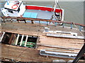
2
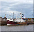
Abauna in Maryport - July 2016
The fishing vessel Abauna (MT55) in Maryport docks.
Image: © The Carlisle Kid
Taken: 3 Jul 2016
0.01 miles
3
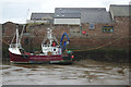
Maryport Harbour
'Alauna', part of Maryport's small trawler fleet, sits on the mud in the harbour on a Sunday afternoon.
Image: © Stephen McKay
Taken: 5 Oct 2014
0.02 miles
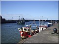
4
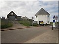
HM Coastguard and Maryport Inshore Rescue buildings
The building on the left is the base of Maryport Inshore Rescue. They are an independent rescue organisation and not part of the RNLI. The building on the right is the Maryport base of HM Coastguard.
Image: © Graham Robson
Taken: 14 Jul 2012
0.02 miles
6
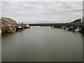
Looking north from the footbridge over the harbour, Maryport
Looking north from the footbridge over the harbour entrance, Maryport. A number of small fishing boats line the sides of dock.
Image: © Graham Robson
Taken: 14 Jul 2012
0.02 miles
8
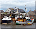
Fredwood in Maryport - July 2016
The Annan registered Fredwood (BA338) and other vessels in Maryport docks.
Image: © The Carlisle Kid
Taken: 3 Jul 2016
0.03 miles
10
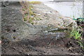
Benchmark on jetty step
Ordnance Survey cut mark benchmark described on the Bench Mark Database at http://www.bench-marks.org.uk/bm43412
Image: © Roger Templeman
Taken: 27 Jun 2012
0.04 miles