IMAGES TAKEN NEAR TO
Mawbray, MARYPORT, CA15 6QY
Introduction
This page details the photographs taken nearby to CA15 6QY by members of the Geograph project.
The Geograph project started in 2005 with the aim of publishing, organising and preserving representative images for every square kilometre of Great Britain, Ireland and the Isle of Man.

There are currently over 7.5m images from over14,400 individuals and you can help contribute to the project by visiting https://www.geograph.org.uk
Image Map
Images are licensed for reuse under creativecommons.org/licenses/by-sa/2.0
Notes
- Clicking on the map will re-center to the selected point.
- The higher the marker number, the further away the image location is from the centre of the postcode.
Image Listing (10 Images Found)
Images are licensed for reuse under creativecommons.org/licenses/by-sa/2.0
Image
Details
Distance
1
In need of a lick of paint
An old Cumberland roadsign at Jericho.
Image: © Matthew Hatton
Taken: 24 May 2014
0.01 miles
2
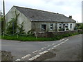
Jericho, near Jordan Beck
This house backs on to Hangingshaw Moss, a lowland raised mire.
Image: © Matthew Hatton
Taken: 24 May 2014
0.01 miles
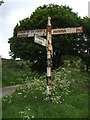
3

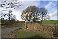
Old Direction Sign - Signpost near Jericho
Pawn finial - 4 arms; Cumberland CC square end by the UC road near Jericho, in parish of Holme St Cuthbert (Allerdale District). By 2023 the HOLME ST CUTHBERT ¾ / MAWBRAY 2 arm had been lost, see https://www.geograph.org.uk/photo/7601249.
To be surveyed
Milestone Society National ID: CU_NY1146
Image: © M Hatton
Taken: 1 Jan 2014
0.01 miles
4
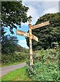
Direction Sign – Signpost near Jericho
Located on the northeast side of a junction at Jericho in Holme St Cuthbert parish. 4 arms, 1 missing, and pawn finial. The fourth arm indicated HOLME ST CUTHBERT ¾ / MAWBRAY 2 and can be seen here https://www.geograph.org.uk/photo/6098544 in 2014.
Milestone Society National ID: CU_NY1146
Image: © B Todd
Taken: 12 Sep 2023
0.01 miles
6
Road junction
Signpost at Jericho road junction
Image: © P Gaskell
Taken: Unknown
0.04 miles
7
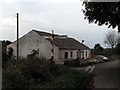
Jericho, near Holme St Cuthbert
The 'village' of Jericho consists of this single farmhouse.
Image: © Nigel Monckton
Taken: 10 Oct 2005
0.08 miles
8
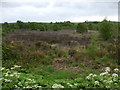
Lowland Raised Mire near Jericho
I was not expecting to see this having been driving through grassland for most of the morning. Hangingshaws Moss is an area of peat left behind during the last ice-age. It is an open access area and attracts many rare species. The township of Goodyhills has rights to cut peat, but no-one has done so for the last 90+ years.
Image: © Matthew Hatton
Taken: 24 May 2014
0.12 miles
9
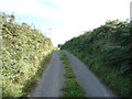
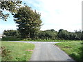
Heading south east from Goodyhills
Towards Jericho.
Image: © JThomas
Taken: 17 Sep 2016
0.14 miles