IMAGES TAKEN NEAR TO
Camp Road, MARYPORT, CA15 6JH
Introduction
This page details the photographs taken nearby to Camp Road, CA15 6JH by members of the Geograph project.
The Geograph project started in 2005 with the aim of publishing, organising and preserving representative images for every square kilometre of Great Britain, Ireland and the Isle of Man.

There are currently over 7.5m images from over14,400 individuals and you can help contribute to the project by visiting https://www.geograph.org.uk
Image Map
Images are licensed for reuse under creativecommons.org/licenses/by-sa/2.0
Notes
- Clicking on the map will re-center to the selected point.
- The higher the marker number, the further away the image location is from the centre of the postcode.
Image Listing (79 Images Found)
Images are licensed for reuse under creativecommons.org/licenses/by-sa/2.0
Image
Details
Distance
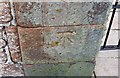
1
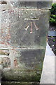
Benchmark on Shandon House, Camp Road
Ordnance Survey cut mark benchmark described on the Bench Mark Database at http://www.bench-marks.org.uk/bm43775
Image: © Roger Templeman
Taken: 27 Jun 2012
0.06 miles
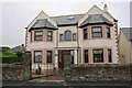
2
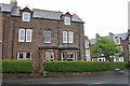
Shandon House, Camp Road at Christian Street junction
There is an OS benchmark Image on a corner stone at the front right of the house
Image: © Roger Templeman
Taken: 27 Jun 2012
0.06 miles
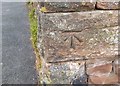
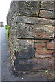
3
Ordnance Survey Cut Mark
This OS cut mark can be found on No76 Camp Road. It marks a point 41.124m above mean sea level.
Image: © Adrian Dust
Taken: 27 Mar 2018
0.06 miles
4
Ordnance Survey Cut Mark
This OS cut mark can be found on the wall NW side of Camp Road. It marks a point 49.091m above mean sea level.
Image: © Adrian Dust
Taken: 27 Mar 2018
0.08 miles
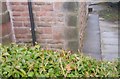
5
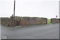
Wall of the Roman Fort at Camp Road/footpath junction
There is an OS benchmark Image on a corner stone of the wall left of the footpath fingerpost pointing towards the coast.
Image: © Roger Templeman
Taken: 27 Jun 2012
0.08 miles
6
Benchmark on the Camp Road corner of the Roman Fort
Ordnance Survey cut mark benchmark described on the Bench Mark Database at http://www.bench-marks.org.uk/bm43779
Image: © Roger Templeman
Taken: 27 Jun 2012
0.08 miles
7
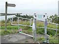
Top of the Fairy Path
Leading from the Upper to the Lower Promenade.
Image: © Oliver Dixon
Taken: 10 Sep 2021
0.10 miles
8
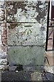
Benchmark on gatepost of house on The Promenade
Ordnance Survey cut mark benchmark described on the Bench Mark Database at http://www.bench-marks.org.uk/bm43783
Image: © Roger Templeman
Taken: 27 Jun 2012
0.11 miles
9
'Firth House 2000', The Promenade
There is an OS benchmark Image on the left hand gatepost of the entrance to the house
Image: © Roger Templeman
Taken: 27 Jun 2012
0.11 miles
10
Ordnance Survey Cut Mark
This OS cut mark can be found on the gatepost of Firth House. It marks a point 39.220m above mean sea level.
Image: © Adrian Dust
Taken: 27 Mar 2018
0.11 miles