IMAGES TAKEN NEAR TO
Lower Church Street, MARYPORT, CA15 6JE
Introduction
This page details the photographs taken nearby to Lower Church Street, CA15 6JE by members of the Geograph project.
The Geograph project started in 2005 with the aim of publishing, organising and preserving representative images for every square kilometre of Great Britain, Ireland and the Isle of Man.

There are currently over 7.5m images from over14,400 individuals and you can help contribute to the project by visiting https://www.geograph.org.uk
Image Map
Images are licensed for reuse under creativecommons.org/licenses/by-sa/2.0
Notes
- Clicking on the map will re-center to the selected point.
- The higher the marker number, the further away the image location is from the centre of the postcode.
Image Listing (215 Images Found)
Images are licensed for reuse under creativecommons.org/licenses/by-sa/2.0
Image
Details
Distance
2
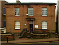
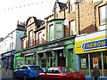
Site of Maryport Brewery Limited - October 2017
First appearing on the 1866 OS Map (but probably much earlier), the Maryport Brewery grew to occupy a substantial site taking in all of Lower Church Street together with the eastern ends of John Street and Wood Street. Acquisition of its Carlisle pubs by the State Management Scheme in 1916 placed great financial strain on the brewery and Hansard (see: http://hansard.millbanksystems.com/commons/1917/jun/27/maryport-brewery-Carlisle ) suggests the brewery made representations to the Government for inclusion in the Scheme. As a result, the Maryport Brewery together with its remaining pubs, stores and other buildings were purchased by the Scheme on 19 June 1917 for a total of £140,000. This effectively doubled Scheme assets overnight and appears to be the reason for the Scheme's expansion beyond Carlisle.
What happened next is still the subject of research, but the brewery is not mentioned by name on the 1925 OS Map. The site appears cleared on the 1961 OS Map, with a part on Lower Church Street developed as "The Palace Ballroom". The houses seen here on left appear on the 1970 OS Map, but "The Palace Ballroom" seems to have been demolished after 1970 and replaced with the modern offices seen in this view.
Image: © The Carlisle Kid
Taken: 27 Oct 2017
0.01 miles
3
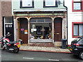
Shop front, Wood Street, Maryport
Until recently 48 Wood Street was home to a shoe shop. Since its close the shop front has been stripped back to reveal an earlier (Victorian?) incarnation.
Image: © Jim Osley
Taken: 28 Jun 2013
0.02 miles
4
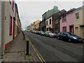
Wood Street, Maryport
A residential street close to the centre of Maryport.
Image: © Graham Robson
Taken: 17 Jun 2016
0.02 miles
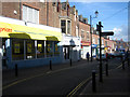
6
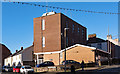
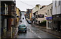
Shops in Senhouse Street
The name "Empire Theatre" is carved in a stone below the semicircular gable to the left. The theatre opened in 1911, it was used as a cinema which closed 1974 http://www.allerdale.gov.uk/downloads/Maryport_Conservation_Area_Appraisal.pdf .
Image: © Rose and Trev Clough
Taken: 30 Sep 2010
0.04 miles
7
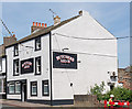
Butchers Arms, Crosby Street, Maryport - June 2017
Early 19th Century pub first mentioned in Slaters Directory of 1848. Still trading.
Photograph is for record only - I have no connection with this business and cannot advise on its products or services.
Image: © The Carlisle Kid
Taken: 19 Jun 2017
0.04 miles
8
The former Empire Theatre, Senhouse Street
Opened as a theatre in 1911, closed as a cinema in 1974.
Image: © Christine Johnstone
Taken: 28 Feb 2013
0.05 miles
9
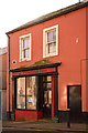
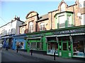
Former "Sun Inn", Wood Street, Maryport - October 2017
First appears in the 1811 "Cumberland Guide & Directory", the "Sun Inn" was acquired by the State Management Scheme in November 1918. No record has been found of its sale, but it appears on the 1970 OS Map.
Now the premises of MANA Credit Union.
Photograph is for record only - I have no connection with MANA Credit Union and cannot advise on their products or services.
Image: © The Carlisle Kid
Taken: 27 Oct 2017
0.05 miles
10
Shops in Senhouse Street
Typical red sandstone buildings; a quiet Sunday afternoon.
Image: © Phil Davies
Taken: 30 Mar 2008
0.05 miles