Site of Maryport Brewery Limited - October 2017
Introduction
The photograph on this page of Site of Maryport Brewery Limited - October 2017 by The Carlisle Kid as part of the Geograph project.
The Geograph project started in 2005 with the aim of publishing, organising and preserving representative images for every square kilometre of Great Britain, Ireland and the Isle of Man.

There are currently over 7.5m images from over 14,400 individuals and you can help contribute to the project by visiting https://www.geograph.org.uk
Site of Maryport Brewery Limited - October 2017
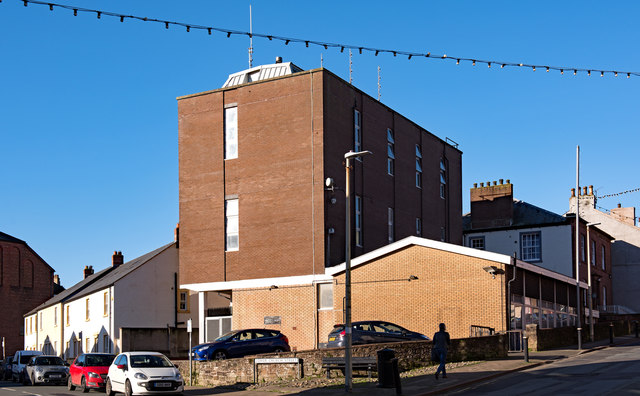
Image: © The Carlisle Kid Taken: 27 Oct 2017
First appearing on the 1866 OS Map (but probably much earlier), the Maryport Brewery grew to occupy a substantial site taking in all of Lower Church Street together with the eastern ends of John Street and Wood Street. Acquisition of its Carlisle pubs by the State Management Scheme in 1916 placed great financial strain on the brewery and Hansard (see: http://hansard.millbanksystems.com/commons/1917/jun/27/maryport-brewery-Carlisle ) suggests the brewery made representations to the Government for inclusion in the Scheme. As a result, the Maryport Brewery together with its remaining pubs, stores and other buildings were purchased by the Scheme on 19 June 1917 for a total of £140,000. This effectively doubled Scheme assets overnight and appears to be the reason for the Scheme's expansion beyond Carlisle. What happened next is still the subject of research, but the brewery is not mentioned by name on the 1925 OS Map. The site appears cleared on the 1961 OS Map, with a part on Lower Church Street developed as "The Palace Ballroom". The houses seen here on left appear on the 1970 OS Map, but "The Palace Ballroom" seems to have been demolished after 1970 and replaced with the modern offices seen in this view.
Images are licensed for reuse under creativecommons.org/licenses/by-sa/2.0
Image Location
Latitude
54.714703
Longitude
-3.496527