IMAGES TAKEN NEAR TO
North Street, MARYPORT, CA15 6HR
Introduction
This page details the photographs taken nearby to North Street, CA15 6HR by members of the Geograph project.
The Geograph project started in 2005 with the aim of publishing, organising and preserving representative images for every square kilometre of Great Britain, Ireland and the Isle of Man.

There are currently over 7.5m images from over14,400 individuals and you can help contribute to the project by visiting https://www.geograph.org.uk
Image Map
Images are licensed for reuse under creativecommons.org/licenses/by-sa/2.0
Notes
- Clicking on the map will re-center to the selected point.
- The higher the marker number, the further away the image location is from the centre of the postcode.
Image Listing (107 Images Found)
Images are licensed for reuse under creativecommons.org/licenses/by-sa/2.0
Image
Details
Distance
1
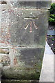
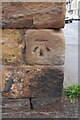
Benchmark on Shandon House, Camp Road
Ordnance Survey cut mark benchmark described on the Bench Mark Database at http://www.bench-marks.org.uk/bm43775
Image: © Roger Templeman
Taken: 27 Jun 2012
0.04 miles
2
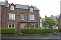
Shandon House, Camp Road at Christian Street junction
There is an OS benchmark Image on a corner stone at the front right of the house
Image: © Roger Templeman
Taken: 27 Jun 2012
0.04 miles
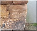
3
Ordnance Survey Cut Mark
This OS cut mark can be found on No76 Camp Road. It marks a point 41.124m above mean sea level.
Image: © Adrian Dust
Taken: 27 Mar 2018
0.04 miles
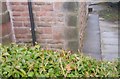
4
Junction of Church Street and North Street
There is an OS benchmark Image on a corner stone of the wall, on its Church Street face
Image: © Roger Templeman
Taken: 27 Jun 2012
0.05 miles
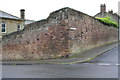
5
Benchmark on Church Street wall at North Street junction
Ordnance Survey cut mark benchmark described on the Bench Mark Database at http://www.bench-marks.org.uk/bm43774
Image: © Roger Templeman
Taken: 27 Jun 2012
0.05 miles
6
Ordnance Survey Cut Mark
This OS cut mark can be found on the junction of Church Street & North Street. It marks a point 34.250m above mean sea level.
Image: © Adrian Dust
Taken: 27 Mar 2018
0.05 miles
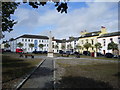
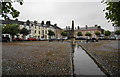
8
Fleming Square
Elegant 18th Century housing in Maryport.
Image: © Oliver Dixon
Taken: 6 Sep 2021
0.08 miles
9
Fleming Square, Maryport
Named after a benefactor of the town.
Image: © Bill Boaden
Taken: 19 Jul 2010
0.08 miles
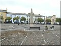
10
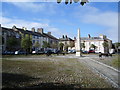
Fleming Square, Maryport
A path from each of the four corners converge on the obelisk, in this tree lined square.
Image: © Alexander P Kapp
Taken: 5 Aug 2007
0.09 miles