IMAGES TAKEN NEAR TO
Senhouse Court, Eaglesfield Street, MARYPORT, CA15 6HF
Introduction
This page details the photographs taken nearby to Senhouse Court, Eaglesfield Street, CA15 6HF by members of the Geograph project.
The Geograph project started in 2005 with the aim of publishing, organising and preserving representative images for every square kilometre of Great Britain, Ireland and the Isle of Man.

There are currently over 7.5m images from over14,400 individuals and you can help contribute to the project by visiting https://www.geograph.org.uk
Image Map
Images are licensed for reuse under creativecommons.org/licenses/by-sa/2.0
Notes
- Clicking on the map will re-center to the selected point.
- The higher the marker number, the further away the image location is from the centre of the postcode.
Image Listing (194 Images Found)
Images are licensed for reuse under creativecommons.org/licenses/by-sa/2.0
Image
Details
Distance
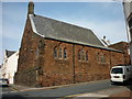
1
Benchmark on the Police Station, Eaglesfield Street
Ordnance Survey cut mark benchmark described on the Bench Mark Database at http://www.bench-marks.org.uk/bm43743
Image: © Roger Templeman
Taken: 21 Jun 2012
0.01 miles
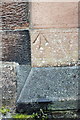
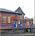
2
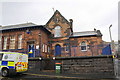
Police Station, Eaglesfield Street
There is an OS benchmark Image on the buttress at the right end of the building
Image: © Roger Templeman
Taken: 21 Jun 2012
0.01 miles
4
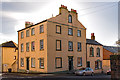
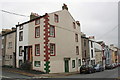
Former "Senhouse Arms", Maryport - October 2017
First appears in the 1811 "Cumberland Guide & Directory" and is shown as an Inn on the 1866 OS Map. The Senhouse Arms was acquired by the State Management Scheme in November 1918 and sold to Greenall Whitley on 23 May 1973, the sale including a builders yard at 133-137 Crosby Street.
Date of closure has not been ascertained. Building is Grade II listed.
Private dwelling with no public access.
Image: © The Carlisle Kid
Taken: 27 Oct 2017
0.02 miles
5
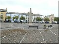
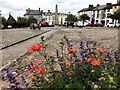
Fleming Square
Elegant 18th Century housing in Maryport.
Image: © Oliver Dixon
Taken: 6 Sep 2021
0.04 miles
7
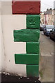
Benchmark on #47 Kirkby Street
Ordnance Survey cut mark benchmark described on the Bench Mark Database at http://www.bench-marks.org.uk/bm43772
Image: © Roger Templeman
Taken: 27 Jun 2012
0.05 miles
8
#47 Kirkby Street at Crosby Street junction
There is an OS benchmark Image on the top green corner stone on the Kirkby Road face
Image: © Roger Templeman
Taken: 27 Jun 2012
0.05 miles
9
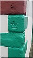
Ordnance Survey Cut Mark
This inverted OS cut mark can be found on No47 Kirkby Street. It marks a point 23.906m above mean sea level.
Image: © Adrian Dust
Taken: 27 Mar 2018
0.05 miles