IMAGES TAKEN NEAR TO
George Street, MARYPORT, CA15 6DT
Introduction
This page details the photographs taken nearby to George Street, CA15 6DT by members of the Geograph project.
The Geograph project started in 2005 with the aim of publishing, organising and preserving representative images for every square kilometre of Great Britain, Ireland and the Isle of Man.

There are currently over 7.5m images from over14,400 individuals and you can help contribute to the project by visiting https://www.geograph.org.uk
Image Map
Images are licensed for reuse under creativecommons.org/licenses/by-sa/2.0
Notes
- Clicking on the map will re-center to the selected point.
- The higher the marker number, the further away the image location is from the centre of the postcode.
Image Listing (270 Images Found)
Images are licensed for reuse under creativecommons.org/licenses/by-sa/2.0
Image
Details
Distance
1
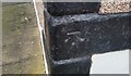
Ordnance Survey Cut Mark
This OS cut mark can be found on No25 High Street. It marks a point 17.627m above mean sea level.
Image: © Adrian Dust
Taken: 27 Mar 2018
0.03 miles
2
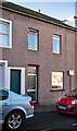
Site of "Artillery Arms" pub, Maryport - October 2017
The "Artillery Arms" appears as an Inn on the 1866 OS Map and was acquired by the State Management Scheme in November 1918. As it is not shown on the 1925 OS Map, it was probably closed by the scheme not long after purchase.
This house seems to be on the approximate site as shown in: https://pubshistory.com/Cumberland/Maryport/ArtilleryArms.shtml , but is obviously modern with no clear trace of the original building.
Private dwelling with no public access.
Image: © The Carlisle Kid
Taken: 27 Oct 2017
0.04 miles
3
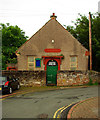
Gospel Hall, Furnace Road, Maryport (1861)
Image: © Jim Osley
Taken: 28 Jun 2013
0.05 miles

5
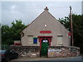
Furness Road, Gospel Hall, Maryport
Image: © Alexander P Kapp
Taken: 5 Aug 2007
0.06 miles
6
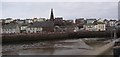
Maryport Harbour
The modern town was founded in 1749 by Humphrey Senhouse II (his wife's name was Mary), to serve as a port for coal and iron ore. This winter view was taken from NY033366 looking NE across the harbour to the church and town.
Image: © Humphrey Bolton
Taken: 3 Jan 2004
0.07 miles
7
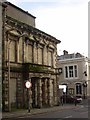
Disused bank, High Street, Maryport
Built with optimism but evidently not sustainable. Let's hope someone can find a good use for this building (not a fast food outlet, please!).
Image: © Humphrey Bolton
Taken: 3 Jan 2004
0.07 miles
8
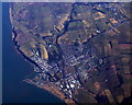
Maryport from the air
The docks and the meanders in the River Ellen can be clearly seen. Viewed from a Brussels bound flight from Prestwick.
Image: © Thomas Nugent
Taken: 1 Mar 2010
0.07 miles
9
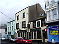
The Crown Inn, Senhouse Street, Maryport
Image: © Alexander P Kapp
Taken: 5 Aug 2007
0.07 miles
10
Mosaic, Mill Race Lonning, Maryport
Mosaic depicting the history of Maryport.
Image: © Jim Osley
Taken: 28 Jun 2013
0.07 miles