IMAGES TAKEN NEAR TO
Curzon Street, MARYPORT, CA15 6BY
Introduction
This page details the photographs taken nearby to Curzon Street, CA15 6BY by members of the Geograph project.
The Geograph project started in 2005 with the aim of publishing, organising and preserving representative images for every square kilometre of Great Britain, Ireland and the Isle of Man.

There are currently over 7.5m images from over14,400 individuals and you can help contribute to the project by visiting https://www.geograph.org.uk
Image Map
Images are licensed for reuse under creativecommons.org/licenses/by-sa/2.0
Notes
- Clicking on the map will re-center to the selected point.
- The higher the marker number, the further away the image location is from the centre of the postcode.
Image Listing (189 Images Found)
Images are licensed for reuse under creativecommons.org/licenses/by-sa/2.0
Image
Details
Distance
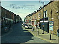
1
Senhouse Street, Maryport
Looking along Senhouse Street, Maryport.
Image: © Graham Robson
Taken: 14 Jul 2012
0.01 miles
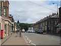
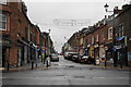
2
Fenhouse Street, Maryport
Looking WNW from Curzon Street
Image: © Kenneth Allen
Taken: 20 Apr 2013
0.01 miles
3
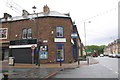
Shop to let at Senhouse Street/Curzon Street junction
There is an OS benchmark Image to the left of the hydrant sign
Image: © Roger Templeman
Taken: 21 Jun 2012
0.01 miles
4
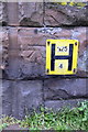
Benchmark and hydrant sign on Senhouse Street shop
The Ordnance Survey cut mark benchmark is described on the Bench Mark Database at http://www.bench-marks.org.uk/bm43745
Image: © Roger Templeman
Taken: 21 Jun 2012
0.01 miles
5
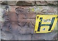
Ordnance Survey Cut Mark
This OS cut mark can be found on the Wedding Hire Shop at the junction of Curzon Street & Senhouse Street. It marks a point 10.461m above mean sea level.
Image: © Adrian Dust
Taken: 27 Mar 2018
0.01 miles
6
Senhouse Street, Maryport
Viewed from its junction with Curzon Street, and looking towards the sea.
Image: © Bill Boaden
Taken: 19 Jul 2010
0.02 miles
8
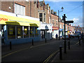
Shops in Senhouse Street
Typical red sandstone buildings; a quiet Sunday afternoon.
Image: © Phil Davies
Taken: 30 Mar 2008
0.03 miles
9
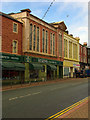
Curzon Street shops, Maryport
Features a former Co-op emporium of 1881.
Image: © Jim Osley
Taken: 28 Jun 2013
0.04 miles
10
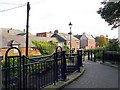
Mill Race Lonning
Footpath to Mill Street Car Park, which starts from a passage in Senhouse Street http://www.geograph.org.uk/photo/744201 .
There is no sign of any water - the Mill Race was filled in during the late 19th century http://www.allerdale.gov.uk/downloads/Maryport_Conservation_Area_Appraisal.pdf .
Houses at the centre of the picture are in Mill Street North.
Image: © Rose and Trev Clough
Taken: 30 Sep 2010
0.04 miles