IMAGES TAKEN NEAR TO
Senhouse Street, MARYPORT, CA15 6BN
Introduction
This page details the photographs taken nearby to Senhouse Street, CA15 6BN by members of the Geograph project.
The Geograph project started in 2005 with the aim of publishing, organising and preserving representative images for every square kilometre of Great Britain, Ireland and the Isle of Man.

There are currently over 7.5m images from over14,400 individuals and you can help contribute to the project by visiting https://www.geograph.org.uk
Image Map
Images are licensed for reuse under creativecommons.org/licenses/by-sa/2.0
Notes
- Clicking on the map will re-center to the selected point.
- The higher the marker number, the further away the image location is from the centre of the postcode.
Image Listing (268 Images Found)
Images are licensed for reuse under creativecommons.org/licenses/by-sa/2.0
Image
Details
Distance
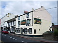
1
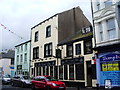
The Crown Inn, Senhouse Street, Maryport
Image: © Alexander P Kapp
Taken: 5 Aug 2007
0.02 miles
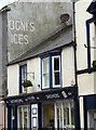
3

White Star Pub - Maryport - July 2016
Closed and currently for sale.
Photograph is for record only - I have no connection with any party involved in the sale of these premises and cannot advise on their products or services.
Image: © The Carlisle Kid
Taken: 3 Jul 2016
0.02 miles
4
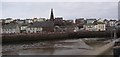
Maryport Harbour
The modern town was founded in 1749 by Humphrey Senhouse II (his wife's name was Mary), to serve as a port for coal and iron ore. This winter view was taken from NY033366 looking NE across the harbour to the church and town.
Image: © Humphrey Bolton
Taken: 3 Jan 2004
0.03 miles
5
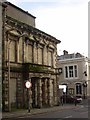
Disused bank, High Street, Maryport
Built with optimism but evidently not sustainable. Let's hope someone can find a good use for this building (not a fast food outlet, please!).
Image: © Humphrey Bolton
Taken: 3 Jan 2004
0.03 miles
6
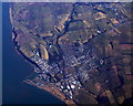
Maryport from the air
The docks and the meanders in the River Ellen can be clearly seen. Viewed from a Brussels bound flight from Prestwick.
Image: © Thomas Nugent
Taken: 1 Mar 2010
0.03 miles
7
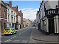
Crosby Street, Maryport
Looking north along Crosby Street, Maryport, with a police car in the foreground.
Image: © Graham Robson
Taken: 14 Jul 2012
0.03 miles
8
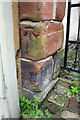
Benchmark on gate post next to #76 High Street
Ordnance Survey cut mark benchmark desscibed on the Bench Mark Database at http://www.bench-marks.org.uk/bm43417
Image: © Roger Templeman
Taken: 27 Jun 2012
0.03 miles
9
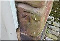
Ordnance Survey Cut Mark
This OS cut mark can be found on No76 High Street. It marks a point 20.102m above mean sea level.
Image: © Adrian Dust
Taken: 27 Mar 2018
0.03 miles
10
The Butchers Arms, High Street, Maryport
Image: © Alexander P Kapp
Taken: 5 Aug 2007
0.04 miles