IMAGES TAKEN NEAR TO
Roper Terrace, WORKINGTON, CA14 5NE
Introduction
This page details the photographs taken nearby to Roper Terrace, CA14 5NE by members of the Geograph project.
The Geograph project started in 2005 with the aim of publishing, organising and preserving representative images for every square kilometre of Great Britain, Ireland and the Isle of Man.

There are currently over 7.5m images from over14,400 individuals and you can help contribute to the project by visiting https://www.geograph.org.uk
Image Map
Images are licensed for reuse under creativecommons.org/licenses/by-sa/2.0
Notes
- Clicking on the map will re-center to the selected point.
- The higher the marker number, the further away the image location is from the centre of the postcode.
Image Listing (19 Images Found)
Images are licensed for reuse under creativecommons.org/licenses/by-sa/2.0
Image
Details
Distance
3

Old boundary stone embedded in the wall of Eller Bank
The stone has Milestone Society National ID: CU_WORK01pb
Image: © Roger Templeman
Taken: 18 Oct 2018
0.11 miles
6
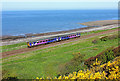
Railway at Harrington
Local train passing Harrington on the Cumbrian Coast Line.
Image: © Wayland Smith
Taken: 25 May 2013
0.17 miles
7
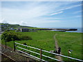
SRPS Cumbrian Coast Railtour 2018 : Approaching Harrington Harbour
Image: © Richard West
Taken: 12 May 2018
0.21 miles
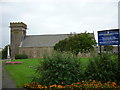
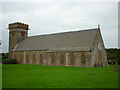
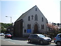
10
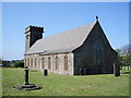
Parish Church of St Mary's, Harrington
Image: © Alexander P Kapp
Taken: 4 May 2007
0.23 miles