IMAGES TAKEN NEAR TO
Falcon Place, WORKINGTON, CA14 2EX
Introduction
This page details the photographs taken nearby to Falcon Place, CA14 2EX by members of the Geograph project.
The Geograph project started in 2005 with the aim of publishing, organising and preserving representative images for every square kilometre of Great Britain, Ireland and the Isle of Man.

There are currently over 7.5m images from over14,400 individuals and you can help contribute to the project by visiting https://www.geograph.org.uk
Image Map
Images are licensed for reuse under creativecommons.org/licenses/by-sa/2.0
Notes
- Clicking on the map will re-center to the selected point.
- The higher the marker number, the further away the image location is from the centre of the postcode.
Image Listing (82 Images Found)
Images are licensed for reuse under creativecommons.org/licenses/by-sa/2.0
Image
Details
Distance
2
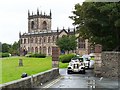
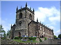
Wedding cars leaving St. Michael's Church
The Parish Church of Workington has been rebuilt and remodelled several times during its long history http://www.stmichaelsworkington.org.uk/history.htm . It has been burnt to a shell twice, most recently in 1994.
Image: © Rose and Trev Clough
Taken: 28 Aug 2010
0.05 miles
3
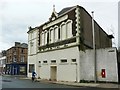
Albert Hall, Fisher Street
The windows have been boarded up fairly recently - when Google Street View passed by the building was occupied by a catering supplies business. The date on the roof is 1883. The Albert Hall was originally used for auction sales, concerts, etc. (Bulmer's History and Directory of Cumberland, 1901 http://www.stevebulman.f9.co.uk/cumbria/1901/work1901_f.html ).
Image: © Rose and Trev Clough
Taken: 28 Aug 2010
0.07 miles
4
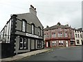
Junction of William Street/South William Street
William Street is round the corner to the left. The curved block with pink and orange paintwork is called Victoria Buildings, dated 1882.
Image: © Rose and Trev Clough
Taken: 28 Aug 2010
0.09 miles
5

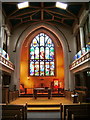
Pulpit, St Michael's Church, Workington
The reason why the interior is so modern is because in 1994 the church was severely damaged by fire. For further information http://www.stmichaelsworkington.org.uk
Image: © Alexander P Kapp
Taken: 2 Aug 2007
0.10 miles
7
Interior, St Michael's Church, Workington
Image: © Alexander P Kapp
Taken: 2 Aug 2007
0.10 miles
8
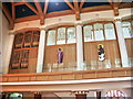
Interior, St Michael's Church, Workington
One of the upper side walls there are four arches on each side
Image: © Alexander P Kapp
Taken: 2 Aug 2007
0.10 miles
9
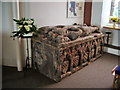
Table tomb, St Michael's Church, Workington
The table tomb of Sir Christopher Curwen and his wife Lady Elizabeth http://www.stmichaelsworkington.org.uk
Image: © Alexander P Kapp
Taken: 2 Aug 2007
0.10 miles
10
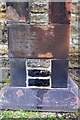
Benchmark on St Michael's Church
Ordnance Survey cut mark benchmark described on the Bench Mark Database at http://www.bench-marks.org.uk/bm43741
Image: © Roger Templeman
Taken: 21 Jun 2012
0.10 miles