IMAGES TAKEN NEAR TO
Siddick Road, WORKINGTON, CA14 1JU
Introduction
This page details the photographs taken nearby to Siddick Road, CA14 1JU by members of the Geograph project.
The Geograph project started in 2005 with the aim of publishing, organising and preserving representative images for every square kilometre of Great Britain, Ireland and the Isle of Man.

There are currently over 7.5m images from over14,400 individuals and you can help contribute to the project by visiting https://www.geograph.org.uk
Image Map
Images are licensed for reuse under creativecommons.org/licenses/by-sa/2.0
Notes
- Clicking on the map will re-center to the selected point.
- The higher the marker number, the further away the image location is from the centre of the postcode.
Image Listing (23 Images Found)
Images are licensed for reuse under creativecommons.org/licenses/by-sa/2.0
Image
Details
Distance
1
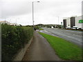
The A596 leaving Workington
Heading for Maryport and Carlisle. The Dunmail Park Shopping Centre is on the right.
Image: © David Purchase
Taken: 4 Oct 2017
0.07 miles
3
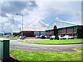
St Helen's Business Park, Workington
Image: © Alexander P Kapp
Taken: 1 Aug 2007
0.09 miles
4

New ASDA store nearly finished
Workington's first ASDA, which took over an existing building at the Dunmail Park shopping centre. Due to open 18 October 2010.
Image: © Rose and Trev Clough
Taken: 30 Sep 2010
0.11 miles
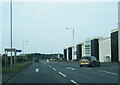
5

Dunmail Park Shopping Centre
A large shopping centre on the northern edge of Workington.
Image: © David Purchase
Taken: 4 Oct 2017
0.11 miles
6
Outside Workington North Station
For background information, see http://www.geograph.org.uk/photo/2115407 . The station had a car park, waiting shelter and lighting.
Workington North was a temporary halt on the Cumbrian Coast railway line between Flimby and Workington.
Image: © Rose and Trev Clough
Taken: 30 Sep 2010
0.11 miles
7
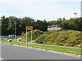
Approach to Workington North Temporary Station
For background information, see http://www.geograph.org.uk/photo/2115407 . The station was built on vacant land owned by Allerdale Borough Council, off the A596 just to the north of Image .
Image: © Rose and Trev Clough
Taken: 30 Sep 2010
0.12 miles
8
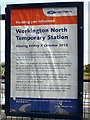
Workington North Station - closure notice
On the southbound platform of Image .
Image: © Rose and Trev Clough
Taken: 30 Sep 2010
0.12 miles
9
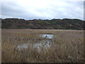
Siddick Ponds Nature Reserve
View from National Cycle Route 72.
Image: © JThomas
Taken: 23 Nov 2019
0.13 miles
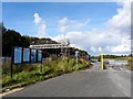
10
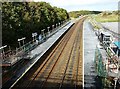
Workington North Temporary Station
This station was built to help people get across the River Derwent, after flood damage put all the road and pedestrian bridges between the north and south sides of Workington out of use. The nearest station north of here is Flimby, about 4.4km along the track. Workington Station is about 1.5km south.
Workington North was constructed by Network Rail in just 6 days, opening on 30 November 2009. The normal timetable was supplemented with hourly free shuttle trains between Workington and Maryport, financed by the Government. Cumbria County Council funded a bus service between the new station and the residential areas of Northside and Seaton. These arrangements ceased in May 2010, after a temporary road bridge was opened and passenger numbers declined.
The temporary station closed on 8th October 2010, and will be dismantled - see Image .
Image: © Rose and Trev Clough
Taken: 30 Sep 2010
0.13 miles