IMAGES TAKEN NEAR TO
Prince Of Wales Dock, WORKINGTON, CA14 1BN
Introduction
This page details the photographs taken nearby to Prince Of Wales Dock, CA14 1BN by members of the Geograph project.
The Geograph project started in 2005 with the aim of publishing, organising and preserving representative images for every square kilometre of Great Britain, Ireland and the Isle of Man.

There are currently over 7.5m images from over14,400 individuals and you can help contribute to the project by visiting https://www.geograph.org.uk
Image Map
Images are licensed for reuse under creativecommons.org/licenses/by-sa/2.0
Notes
- Clicking on the map will re-center to the selected point.
- The higher the marker number, the further away the image location is from the centre of the postcode.
Image Listing (29 Images Found)
Images are licensed for reuse under creativecommons.org/licenses/by-sa/2.0
Image
Details
Distance
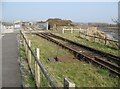
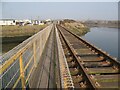
1
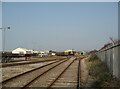
Railway sidings, Workington Docks
The sidings in the foreground cross over the River Derwent on the Workington Dock or Harbour Bridge to connect with the Workington Steelworks internal railway system.
Image: © Adrian Taylor
Taken: 19 Mar 2009
0.10 miles
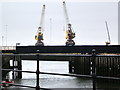
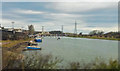
2
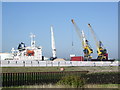
Workington Docks
The "Arctic Sky" being unloaded,
Image: © Alexander P Kapp
Taken: 3 May 2007
0.11 miles
4
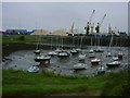
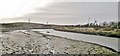
Workington
Workington Harbour, once an important port for exporting west Cumbrian coal.
Image: © Carl Bendelow
Taken: 11 Jul 2000
0.12 miles
5
Railway into Workington Docks
The railway is mainly used for transporting steel rails for export and connects Workington Docks with the internal Workington Steelworks railway system, via the Workington Dock or Harbour Bridge.
The footpath leads from Curwen Road to Northside, it is also the Cumbria Coastal Way and part of National Cycle Route 71.
Image: © Adrian Taylor
Taken: 19 Mar 2009
0.13 miles
6
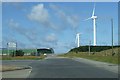
Windfarm at Workington
Magnifiscent giants.
Image: © Margaret Morgan
Taken: 8 Jul 2007
0.14 miles
7
Workington Town Quay
A mid-March view taken from a train on the Cumbrian Coast line.
Image: © Mary and Angus Hogg
Taken: 21 Mar 2016
0.15 miles
8
Workington Dock or Harbour Bridge
The north eastern part of this combined railway and footpath bridge crosses the River Derwent. The bridge carries the railway from Workington Steelworks to Workington Dock, mainly used for transporting rails for export. The footpath leads from Curwen Road to Northside and is part of the Cumbria Coastal Way; National Cycle Route 71 also follows the same very narrow path.
Image: © Adrian Taylor
Taken: 19 Mar 2009
0.15 miles