IMAGES TAKEN NEAR TO
Parkland Drive, CARLISLE, CA1 3GQ
Introduction
This page details the photographs taken nearby to Parkland Drive, CA1 3GQ by members of the Geograph project.
The Geograph project started in 2005 with the aim of publishing, organising and preserving representative images for every square kilometre of Great Britain, Ireland and the Isle of Man.

There are currently over 7.5m images from over14,400 individuals and you can help contribute to the project by visiting https://www.geograph.org.uk
Image Map
Images are licensed for reuse under creativecommons.org/licenses/by-sa/2.0
Notes
- Clicking on the map will re-center to the selected point.
- The higher the marker number, the further away the image location is from the centre of the postcode.
Image Listing (14 Images Found)
Images are licensed for reuse under creativecommons.org/licenses/by-sa/2.0
Image
Details
Distance
3
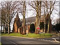
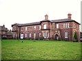
Converted hospital chapel
Built in 1875 to serve the Cumberland and Westmorland Asylum, which later became Garlands Hospital. Most of the hospital site became surplus to requirements in the 1990s and was redeveloped with housing. The grade II listed chapel has been converted to eight apartments.
The chapel development was named Worthington Place after the architect who designed the asylum, Thomas Worthington http://en.wikipedia.org/wiki/Thomas_Worthington_(architect) . English Heritage attributes the chapel to JA Cory, county surveyor http://www.imagesofengland.org.uk/Details/Default.aspx?id=468935&mode=adv .
Image: © Rose and Trev Clough
Taken: 19 Jan 2010
0.15 miles
5
Converted hospital building
A plaque over the right-hand door gives the date, 1862. It was originally the administration building of the Cumberland and Westmorland Lunatic Asylum, which later became the Garlands Hospital. Most of the hospital site became available for redevelopment in the late 1990s. The buildings surrounding this renovated block were demolished and replaced with smart new houses.
English Heritage Archives has a photo of the hospital building still in use http://www.englishheritagearchives.org.uk/SingleResult/Default.aspx?id=105283&parent=1302918 .
Image: © Rose and Trev Clough
Taken: 19 Jan 2010
0.17 miles
6

Welcome to Parkland Village
A large housing development, early to mid 2000s. It occupies most of the old Garlands Hospital estate, and includes new build houses and apartments plus converted existing buildings.
Image: © Rose and Trev Clough
Taken: 19 Jan 2010
0.18 miles
7
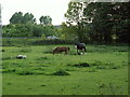
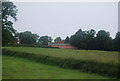
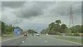
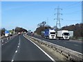
Grazing beside the M6
Horses and sheep grazing beside the M6 south of Lough Butts Wood. Taken from the bridleway.
Image: © Rose and Trev Clough
Taken: 26 May 2007
0.18 miles
9
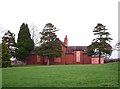
Burnamwood
Boarded up building off Cumwhinton Drive, on the Carleton Clinic NHS site.
The property was formerly part of Garlands Hospital, which was originally the Cumberland and Westmorland Lunatic Asylum. According to the website "County Asylums" http://www.countyasylums.com/mentalasylums/cumberland.htm this building was the isolation hospital, dating from 1896/7.
Information update, January 2019 : since this photo was taken, the building has been demolished.
Image: © Rose and Trev Clough
Taken: 19 Jan 2010
0.20 miles