IMAGES TAKEN NEAR TO
CA1 3BZ
Introduction
This page details the photographs taken nearby to CA1 3BZ by members of the Geograph project.
The Geograph project started in 2005 with the aim of publishing, organising and preserving representative images for every square kilometre of Great Britain, Ireland and the Isle of Man.

There are currently over 7.5m images from over14,400 individuals and you can help contribute to the project by visiting https://www.geograph.org.uk
Image Map
Images are licensed for reuse under creativecommons.org/licenses/by-sa/2.0
Notes
- Clicking on the map will re-center to the selected point.
- The higher the marker number, the further away the image location is from the centre of the postcode.
Image Listing (14 Images Found)
Images are licensed for reuse under creativecommons.org/licenses/by-sa/2.0
Image
Details
Distance
1
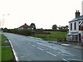
Garlands and Cumwhinton Turning
On the A6 at Carleton, approaching Carlisle. The side road on the right leads to two smaller villages.
Image: © Roger May
Taken: 8 Sep 2005
0.06 miles
2
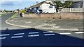
Junction of Farbrow Road and Mallyclose Drive
Ordnance Survey records indicate that a benchmark levelled at 49.841m above Newlyn Datum was verified in 1972 on the surround of the manhole cover in the pavement at this corner. See www.bench-marks.org.uk/bm74947
Image: © Roger Templeman
Taken: 21 Oct 2021
0.12 miles
3
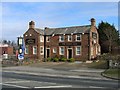
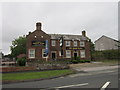
The Green Bank, Carleton
An inn on the A6 on the southern edge of Carlisle known locally as "The Greenie Bank".
Image: © Brian Norman
Taken: 23 Feb 2013
0.12 miles
4
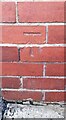
Benchmark on NW face of #504 London Road
Ordnance Survey cut mark benchmark levelled at 49.140m above Newlyn Datum verified 1972
Image: © Roger Templeman
Taken: 21 Oct 2021
0.13 miles
5
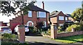
Nos. 504 and 502 London Road
There is an Ordnance Survey benchmark Image on the right hand side of the left hand house (#504, Springbank) at its front corner
Image: © Roger Templeman
Taken: 21 Oct 2021
0.13 miles
6
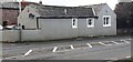
Pebbledashed building on SW side of A6 at Carleton Farm Mews
This is the location of an office on which a benchmark was levelled at 155.043 feet above Liverpool Datum during the Ordnance Survey 1GL Liverpool to Port Carlisle 1841-1844 Survey. The surveyor's description was 'No. 462. Mark on South-east corner of Mr. Moffit's office ; 2.54 ft. above surface of road'. Whether or not this is the same building, the benchmark will have been lost to the pebbledash
Image: © Roger Templeman
Taken: 8 Feb 2022
0.15 miles
8
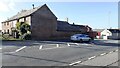
Carleton Farm Mews on SW side of A6
There is an Ordnance Survey benchmark Image at pavement level on the left hand corner, road face, of the left hand barn conversion
Image: © Roger Templeman
Taken: 21 Oct 2021
0.17 miles
9
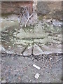
Ordnance Survey Cut Mark
This OS cut mark can be found on the roadside wall at Carleton Farm. It marks a point 48.199m above mean sea level.
Image: © Adrian Dust
Taken: 11 Apr 2016
0.17 miles
10
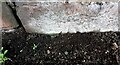
Benchmark at pavement level on roadside Carleton Farm building
Ordnance Survey cut mark benchmark described on the Bench Mark Database at www.bench-marks.org.uk/bm74945
Image: © Roger Templeman
Taken: 21 Oct 2021
0.17 miles