IMAGES TAKEN NEAR TO
Meade Road, CARLISLE, CA1 3BW
Introduction
This page details the photographs taken nearby to Meade Road, CA1 3BW by members of the Geograph project.
The Geograph project started in 2005 with the aim of publishing, organising and preserving representative images for every square kilometre of Great Britain, Ireland and the Isle of Man.

There are currently over 7.5m images from over14,400 individuals and you can help contribute to the project by visiting https://www.geograph.org.uk
Image Map
Images are licensed for reuse under creativecommons.org/licenses/by-sa/2.0
Notes
- Clicking on the map will re-center to the selected point.
- The higher the marker number, the further away the image location is from the centre of the postcode.
Image Listing (50 Images Found)
Images are licensed for reuse under creativecommons.org/licenses/by-sa/2.0
Image
Details
Distance
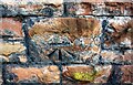
2
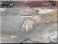
Wall and woodland on SE side of Petteril Bank Road
There is an Ordnance Survey benchmark Image on a stone in the wall about 4m left of the lamppost
Image: © Luke Shaw
Taken: 24 Aug 2019
0.15 miles
3
O.S Cut Benchmark at Petteril Bank Road, Carlisle
In good condition on a roadside wall.
Image: © David Bremner
Taken: 10 Jun 2022
0.15 miles
4
Stone wall on SE side of Petteril Bank Road opposite No. 18
There is an Ordnance Survey benchmark Image on the large rectangular stone in the wall near the right hand edge of the image
Image: © Luke Shaw
Taken: 24 Aug 2019
0.15 miles
5
Benchmark on wall on SE side of Petteril Bank Road
Ordnance Survey cut mark benchmark described on the Bench Mark Database at www.bench-marks.org.uk/bm103221
Image: © Luke Shaw
Taken: 24 Aug 2019
0.15 miles
6
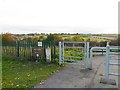
Gate in Petteril Valley Park
Near the end of Woodsghyll Drive. The gate separates an area with mown grass from rough vegetation down the slope.
With good views over the Petteril Valley, the park has hay meadows, a small wood and riverside walks. It belongs to Carlisle City Council, whose old website had some interesting information now only available from Internet Archive - see Petteril Valley natural history http://web.archive.org/web/20130424135210/http://www.carlisle.gov.uk/leisure_and_culture/parks_and_open_spaces/park_locations/petteril_valley/petteril_valley_nat_history.aspx and wildlife http://web.archive.org/web/20130424125847/http://www.carlisle.gov.uk/leisure_and_culture/parks_and_open_spaces/park_locations/petteril_valley/petteril_valley_wildlife.aspx .
Image: © Rose and Trev Clough
Taken: 31 Oct 2010
0.16 miles
7
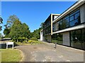
Carlisle Archive Centre, Lady Gillford's House
This building was opened in 2011 when the Carlisle Archives were moved from the Alma Block in Carlisle Castle. The Archive Centre adjoins the Carlisle Registration Office, formerly Petteril Bank House, the old and new buildings being linked by a glass corridor.
Image: © Adrian Taylor
Taken: 3 Jun 2023
0.16 miles
8
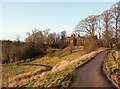
Recently laid pathways at Petteril Bank
The path on the left leads to the Petteril valley - popular with dog walkers. The one on the right goes to Image, seen through the trees.
Image: © Rose and Trev Clough
Taken: 25 Jan 2009
0.16 miles
9
Benchmark on south side of Petteril Bank Road
Ordnance Survey cut mark benchmark described on the Bench Mark Database at www.bench-marks.org.uk/bm103220
Image: © Luke Shaw
Taken: 24 Aug 2019
0.16 miles
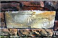
10
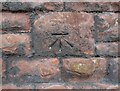
Benchmark, Lady Gillford?s House garden wall
Detail of an Ordnance Survey cut benchmark on the garden wall of Lady Gillford’s House, facing onto Petteril Bank Road. The benchmark marks a height of 38.1717m above mean sea level (Ordnance Datum Newlyn) last verified in 1972 (location photograph Image).
Lady Gillford’s House is the Carlisle Registration Office and the Carlisle Archive Centre.
Image: © Adrian Taylor
Taken: 12 Sep 2021
0.16 miles