IMAGES TAKEN NEAR TO
Routenbeck, COCKERMOUTH, CA13 9YN
Introduction
This page details the photographs taken nearby to CA13 9YN by members of the Geograph project.
The Geograph project started in 2005 with the aim of publishing, organising and preserving representative images for every square kilometre of Great Britain, Ireland and the Isle of Man.

There are currently over 7.5m images from over14,400 individuals and you can help contribute to the project by visiting https://www.geograph.org.uk
Image Map
Images are licensed for reuse under creativecommons.org/licenses/by-sa/2.0
Notes
- Clicking on the map will re-center to the selected point.
- The higher the marker number, the further away the image location is from the centre of the postcode.
Image Listing (25 Images Found)
Images are licensed for reuse under creativecommons.org/licenses/by-sa/2.0
Image
Details
Distance
1
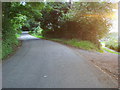
Road to Wythop Mill
Road to Wythop Mill by Sale Fell house
Image: © Shaun Ferguson
Taken: 2 Sep 2010
0.02 miles
2
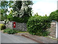
VR postbox, Routenbeck
On the north side of the minor road.
Image: © Christine Johnstone
Taken: 14 Jun 2016
0.03 miles
3
Red squirrel at Routenbeck.
A red squirrel feeding in the garden and hungry enough to be captured by camera.
Image: © John Holmes
Taken: 25 Dec 2005
0.04 miles
4
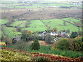
Looking down the hillside to Routenbeck
Looking down the steep side of Sale Fell to the houses and farm at Routenbeck.
Image: © Graham Robson
Taken: 6 Nov 2012
0.05 miles
5
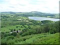
Routenbeck from Sale Fell
The hamlet is about 150 metres below.
Image: © Christine Johnstone
Taken: 14 Jun 2016
0.05 miles
6
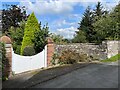
Gateway, Routenbeck House
The gateway of Routenbeck House, Routenbeck. There is an Ordnance Survey cut benchmark facing the road on the corner of the wall beyond the gateway (detail photograph Image).
Image: © Adrian Taylor
Taken: 9 Sep 2023
0.06 miles
7
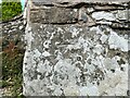
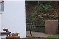
Benchmark, Routenbeck House, Routenbeck
A very worn Ordnance Survey cut benchmark well concealed by lichens on the stone wall beside the gate of Routenbeck House. The benchmark marks a height of 113.3978m above mean sea level (Ordnance Datum Newlyn) last verified in 1956 (location photograph Image).
Image: © Adrian Taylor
Taken: 9 Sep 2023
0.06 miles
8
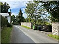
Routenbeck
The minor road from Dubwath to Wythop Mill at Routenbeck.
Image: © Adrian Taylor
Taken: 9 Sep 2023
0.07 miles
9
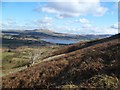
On Sale Fell
On the north flank looking over Bassenthwaite Lake towards Binsey.
Image: © Michael Graham
Taken: 13 Mar 2013
0.09 miles
10
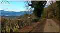
The road at Routenbeck, below Sale Fell
Image: © Gordon Brown
Taken: 14 Feb 2023
0.13 miles