IMAGES TAKEN NEAR TO
Market Street, COCKERMOUTH, CA13 9NP
Introduction
This page details the photographs taken nearby to Market Street, CA13 9NP by members of the Geograph project.
The Geograph project started in 2005 with the aim of publishing, organising and preserving representative images for every square kilometre of Great Britain, Ireland and the Isle of Man.

There are currently over 7.5m images from over14,400 individuals and you can help contribute to the project by visiting https://www.geograph.org.uk
Image Map
Images are licensed for reuse under creativecommons.org/licenses/by-sa/2.0
Notes
- Clicking on the map will re-center to the selected point.
- The higher the marker number, the further away the image location is from the centre of the postcode.
Image Listing (409 Images Found)
Images are licensed for reuse under creativecommons.org/licenses/by-sa/2.0
Image
Details
Distance
1

Cockermouth Town Hall
Originally built ca 1840 as a Wesleyan chapel, this building was converted into the town hall in 1934. It is a Grade II listed building (English Heritage Building ID: 71738 http://www.britishlistedbuildings.co.uk/en-71738-town-hall-cockermouth-cumbria British Listed Buildings).
Image: © David Dixon
Taken: 12 Apr 2014
0.00 miles
2

Cockermouth Town Hall
A closer view of the building shown here Image .
For architectural details, and a photo taken in 2002 when it was a different colour, see English Heritage's Images of England http://www.imagesofengland.org.uk/Details/default.aspx?pid=2&id=71738 .
The lions look grand, but are those fried eggs on the roof?
Image: © Rose and Trev Clough
Taken: 25 Oct 2014
0.01 miles
3

Passage Behind All Saints' Church
Passage way behind Image
Image: © David Dixon
Taken: 12 Apr 2014
0.01 miles
4

Tourist Information Office, Cockermouth
A rather imposing building for a tourist information office?
Image: © Alexander P Kapp
Taken: 19 Jun 2007
0.01 miles
5

Cockermouth Town Hall, Cumbria
Built in 1934
Image: © Andrew Tryon
Taken: 17 Aug 2015
0.01 miles
6

Town hall, Cockermouth
It is located at Market Street
Image: © Kenneth Allen
Taken: 20 Apr 2013
0.02 miles
7

The Old Armoury, Cockermouth
Located on the access road for Riverside car park, behind houses in Market Street.
During the 19th century this was an armoury belonging to the Cockermouth contingent of the Westmorland and Cumberland Yeomanry. The men drilled on land now occupied by Image . Information from Bradbury's History of Cockermouth http://www.amazon.co.uk/Bradburys-History-Cockermouth-J-Bernard-Bradbury/dp/0952981203 .
In the later 20th century, the Tourist Information Centre was in this building. The sign indicates its most recent use as a craft studio, but it appears to be currently disused.
Another view here Image .
Image: © Rose and Trev Clough
Taken: 25 Oct 2014
0.02 miles
8

The Old Armoury - view towards the Town Hall
Located on the access road for Riverside car park, behind houses in Market Street.
During the 19th century this was an armoury belonging to the Cockermouth contingent of the Westmorland and Cumberland Yeomanry. The men drilled on land now occupied by Image . Information from Bradbury's History of Cockermouth http://www.amazon.co.uk/Bradburys-History-Cockermouth-J-Bernard-Bradbury/dp/0952981203 .
In the later 20th century, the Tourist Information Centre was in this building. The sign indicates its most recent use as a craft studio, but it appears to be currently disused.
Another view here Image .
Image: © Rose and Trev Clough
Taken: 25 Oct 2014
0.02 miles
9

Ordnance Survey 1GL Bolt
This OS Bolt can be found on the west face of All Saints Church. It marks a point 55.510m above mean sea level.
Image: © Adrian Dust
Taken: 27 Mar 2018
0.03 miles
10
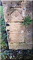
Benchmark on buttress of All Saints' Church
Ordnance Survey 1GL bolt benchmark levelled at 55.510m above Newlyn Datum verified in 1969, but originally levelled at 181.592 feet above Liverpool Datum during the 1855/6 Penrith to Workington 1GL Survey when the surveyor described it as 'Branch Levelling. Mark 69. All Saints' Church, Cockermouth. Bolt in West angle ; 1.94 ft. above surface'
Image: © Roger Templeman
Taken: 19 Dec 2023
0.03 miles