IMAGES TAKEN NEAR TO
Masons Court, COCKERMOUTH, CA13 9LY
Introduction
This page details the photographs taken nearby to Masons Court, CA13 9LY by members of the Geograph project.
The Geograph project started in 2005 with the aim of publishing, organising and preserving representative images for every square kilometre of Great Britain, Ireland and the Isle of Man.

There are currently over 7.5m images from over14,400 individuals and you can help contribute to the project by visiting https://www.geograph.org.uk
Image Map
Images are licensed for reuse under creativecommons.org/licenses/by-sa/2.0
Notes
- Clicking on the map will re-center to the selected point.
- The higher the marker number, the further away the image location is from the centre of the postcode.
Image Listing (444 Images Found)
Images are licensed for reuse under creativecommons.org/licenses/by-sa/2.0
Image
Details
Distance
2
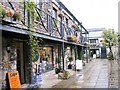
Cockton's Yard
A row of early 19th century workers' houses, built on what was a medieval burgage plot (long narrow strip of land behind a town house fronting onto the street). Pedestrian access to the yard is a passageway between shops on Main Street, modern residents also have car parking spaces to the rear.
The scene doesn't appear to have changed since this photo was taken in 2003 Image .
Image: © Rose and Trev Clough
Taken: 27 Jun 2014
0.01 miles
3
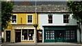
Harrison / Annabelles, Cockermouth
They are located at Main Street
Image: © Kenneth Allen
Taken: 20 Apr 2013
0.02 miles
4
Shops in Main Street Cockermouth
Afternoon sunshine lit up the shops in Cockermouth.
Image: © Jennifer Petrie
Taken: 14 Oct 2019
0.02 miles
5
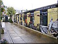
The History Wall
The view in Kings Arms Lane off Main Street, Cockermouth.
Image: © Gordon Griffiths
Taken: 10 Sep 2012
0.02 miles
6
The Old Kings Arms Lane
The view in Kings Arms courtyard off Main Street, Cockermouth.
Image: © Gordon Griffiths
Taken: 10 Sep 2012
0.02 miles
7
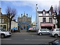
United Reformed Church, Cockermouth
It is located off Main Street
Image: © Kenneth Allen
Taken: 20 Apr 2013
0.02 miles
8
Calm Before no Storm
Main Street, Cockermouth; looking towards the north. Despite the colour of the sky, no rain fell.
Image: © Peter Trimming
Taken: 7 Jul 2015
0.03 miles
9
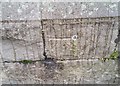
Ordnance Survey 1GL Bolt
This OS Bolt can be found on the south face of the chapel on Main Street. It marks a point 44.772m above mean sea level.
Image: © Adrian Dust
Taken: 27 Mar 2018
0.03 miles
10
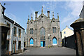
United Reformed Church, Main Street, Cockermouth
Grade II Listed church of 1856. The Cockermouth United Reformed Church (from 1972) was established in 1651 as the Cockermouth Independent Church and later the Congregational Church. An early 18th century chapel (1719 replaced 1735), now a dwelling, previously the Sunday school, stands behind the present building. The listing dates the building to 1856 but it opened under the stewardship of Reverend Portas Hewart Davison on 11th September 1850. It was built at a cost of £2,200 and contained sufficient seating for 500. Major modifications took place in the early 1990s when the church was divided horizontally; the lower part being converted into a general purpose function room with kitchen and toilets while the upper floor remained as the place of worship.
Image: © Jo and Steve Turner
Taken: 11 Jun 2023
0.03 miles