IMAGES TAKEN NEAR TO
Lorton Road, COCKERMOUTH, CA13 9EB
Introduction
This page details the photographs taken nearby to Lorton Road, CA13 9EB by members of the Geograph project.
The Geograph project started in 2005 with the aim of publishing, organising and preserving representative images for every square kilometre of Great Britain, Ireland and the Isle of Man.

There are currently over 7.5m images from over14,400 individuals and you can help contribute to the project by visiting https://www.geograph.org.uk
Image Map
Images are licensed for reuse under creativecommons.org/licenses/by-sa/2.0
Notes
- Clicking on the map will re-center to the selected point.
- The higher the marker number, the further away the image location is from the centre of the postcode.
Image Listing (14 Images Found)
Images are licensed for reuse under creativecommons.org/licenses/by-sa/2.0
Image
Details
Distance
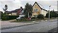
1
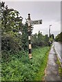
Direction Sign – Signpost on Lorton Road, Cockermouth
Located on the southwest side of the junction of the B5292 Lorton Road and Strawberry How Road in Cockermouth parish. 1 arm and pawn finial.
Milestone Society National ID: CU_NY1229
Image: © B Todd
Taken: 12 Sep 2023
0.05 miles
2
B5292 viewed from west end of Strawberry How Road
There is an old finger signpost Image on the far verge
Image: © Roger Templeman
Taken: 24 Aug 2024
0.05 miles
3
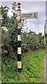
Finger signpost on SW side of B5292 opposite Strawberry How Road
Image is another image of this signpost
Image: © Roger Templeman
Taken: 24 Aug 2024
0.05 miles
4

Former Grammar School, Cockermouth
Now private residences.Strawberry How Rd
Image: © John Lord
Taken: 8 Sep 2009
0.07 miles
5
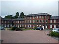
Strawberry How
Once this building was Cockermouth Grammar School, until 1991 when it was closed, it was then converted into an business park, when in 2004 it had another change when it was converted into housing
Image: © Alexander P Kapp
Taken: 4 Sep 2007
0.07 miles
6
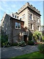
The Towers, Cockermouth
19th Century house, divided into two apartments.
Image: © Oliver Dixon
Taken: 8 Sep 2021
0.11 miles
7
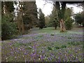
Cockermouth Cemetery
Snowdrops and crocuses carpet the ground in Cockermouth Cemetery.
Image: © Richard Thomas
Taken: 8 Mar 2014
0.11 miles
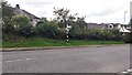
8
Houses on east side of Ellermire Drive at junction with Strawberry How Road
Image: © Roger Templeman
Taken: 24 Aug 2024
0.14 miles
9

Cockermouth Cemetery
The chapels, seen from the Lorton Road entrance.
Image: © Peter Trimming
Taken: 7 Jul 2015
0.17 miles
10

Cockermouth Cemetery, Cumbria
The chapels at the main entrance to Cockermouth Cemetery
Image: © Andrew Tryon
Taken: 17 Aug 2015
0.17 miles