IMAGES TAKEN NEAR TO
Redmain, COCKERMOUTH, CA13 0QA
Introduction
This page details the photographs taken nearby to CA13 0QA by members of the Geograph project.
The Geograph project started in 2005 with the aim of publishing, organising and preserving representative images for every square kilometre of Great Britain, Ireland and the Isle of Man.

There are currently over 7.5m images from over14,400 individuals and you can help contribute to the project by visiting https://www.geograph.org.uk
Image Map
Images are licensed for reuse under creativecommons.org/licenses/by-sa/2.0
Notes
- Clicking on the map will re-center to the selected point.
- The higher the marker number, the further away the image location is from the centre of the postcode.
Image Listing (5 Images Found)
Images are licensed for reuse under creativecommons.org/licenses/by-sa/2.0
Image
Details
Distance
1
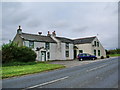
Williamsgate
As you stand there taking photographs you sometimes get the feeling as to why they put up signs saying 1254 casualties in the last 5 years on this road they are right
Image: © Alexander P Kapp
Taken: 3 Sep 2007
0.03 miles
2
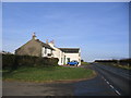
Williamsgate
Right on the edge of the busy A595 where the Roman road (very straight) starts makes me wonder about the name.
Image: © John Holmes
Taken: 19 Nov 2005
0.07 miles
3
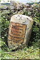
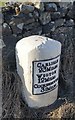
Old Milestone by the A595, north east of Williamsgate
Metal plate attached to stone post by the A595, in parish of BLINDCRAKE (ALLERDALE District), North East of southern lane into Blindcrake, by the road, on West side of road. Carlisle red stone and curved plate, erected by the Cockermouth & Carlisle turnpike trust in the 19th century.
Inscription reads:-
CARLISLE
23 MILES
WIGTON
12 MILES
COCKERMOUTH
3½ MILES
Carved benchmark and rivet on top.
Milestone Society National ID: CU_CLCM23.
Image: © C Minto
Taken: 2 Aug 2004
0.17 miles
4
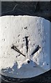
Ordnance Survey Rivet
This OS rivet can be found on the Milestone. It marks a point 160.371m above mean sea level. http://www.geograph.org.uk/photo/5721149
Image: © Adrian Dust
Taken: 26 Mar 2018
0.17 miles
5
Milestone - Carlisle 22
There is an Ordnance Survey rivet on the top of the stone. http://www.geograph.org.uk/photo/5721146
Image: © Adrian Dust
Taken: 26 Mar 2018
0.17 miles