Old Milestone by the A595, north east of Williamsgate
Introduction
The photograph on this page of Old Milestone by the A595, north east of Williamsgate by C Minto as part of the Geograph project.
The Geograph project started in 2005 with the aim of publishing, organising and preserving representative images for every square kilometre of Great Britain, Ireland and the Isle of Man.

There are currently over 7.5m images from over 14,400 individuals and you can help contribute to the project by visiting https://www.geograph.org.uk
Old Milestone by the A595, north east of Williamsgate
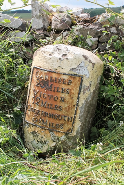
Image: © C Minto Taken: 2 Aug 2004
Metal plate attached to stone post by the A595, in parish of BLINDCRAKE (ALLERDALE District), North East of southern lane into Blindcrake, by the road, on West side of road. Carlisle red stone and curved plate, erected by the Cockermouth & Carlisle turnpike trust in the 19th century. Inscription reads:- CARLISLE 23 MILES WIGTON 12 MILES COCKERMOUTH 3½ MILES Carved benchmark and rivet on top. Milestone Society National ID: CU_CLCM23.
Images are licensed for reuse under creativecommons.org/licenses/by-sa/2.0
Image Location
Latitude
54.69867
Longitude
-3.338122