IMAGES TAKEN NEAR TO
St. Leonards Close, COCKERMOUTH, CA13 0JA
Introduction
This page details the photographs taken nearby to St. Leonards Close, CA13 0JA by members of the Geograph project.
The Geograph project started in 2005 with the aim of publishing, organising and preserving representative images for every square kilometre of Great Britain, Ireland and the Isle of Man.

There are currently over 7.5m images from over14,400 individuals and you can help contribute to the project by visiting https://www.geograph.org.uk
Image Map
Images are licensed for reuse under creativecommons.org/licenses/by-sa/2.0
Notes
- Clicking on the map will re-center to the selected point.
- The higher the marker number, the further away the image location is from the centre of the postcode.
Image Listing (181 Images Found)
Images are licensed for reuse under creativecommons.org/licenses/by-sa/2.0
Image
Details
Distance
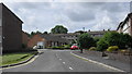
2
Manor Court, Wakefield Road
A sheltered housing complex, built in the 1960s. The flats suffered damage in the November 2009 floods, and were demolished in 2010.
A new housing development for the over-55s, called Bridge End Court, has been built on the site.
Image: © Rose and Trev Clough
Taken: 22 Nov 2008
0.04 miles
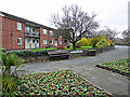
3
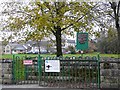
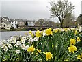
Entrance to Memorial Gardens
This gate on Wakefield Road leads to a pleasant riverside park. The white notice says this is a "Designated Public Place", where the police can ask you to stop drinking alcohol and/or confiscate your drink.
Image: © Rose and Trev Clough
Taken: 22 Nov 2008
0.06 miles
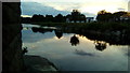
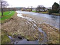
7
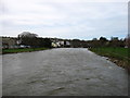
The River Derwent at Cockermouth
Looking downstream from Millers Bridge.
There had been heavy rain for the last three days, so the river was fast-flowing and looks quite high. But this is nothing compared to what Cockermouth has had to endure in recent years.
Image: © David Purchase
Taken: 20 Mar 2017
0.09 miles
8

Lawsons Haulage Ltd
The offices for a local haulage firm, looking at the building it was probably an old corn mill in another life
Image: © Alexander P Kapp
Taken: 5 Jun 2007
0.09 miles
9
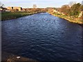
River Derwent from Gote Bridge, Cockermouth
River Derwent taken from Gote Bridge, Cockermouth.
Image: © Richard Thomas
Taken: 2 Apr 2017
0.09 miles
10
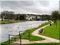
River Derwent in November
The dog is waiting for its owner to throw a stick. Memorial Gardens, with a riverside footpath, are on the left bank.
Image: © Rose and Trev Clough
Taken: 22 Nov 2008
0.09 miles