IMAGES TAKEN NEAR TO
Merith Avenue, CARLISLE, CA1 2TW
Introduction
This page details the photographs taken nearby to Merith Avenue, CA1 2TW by members of the Geograph project.
The Geograph project started in 2005 with the aim of publishing, organising and preserving representative images for every square kilometre of Great Britain, Ireland and the Isle of Man.

There are currently over 7.5m images from over14,400 individuals and you can help contribute to the project by visiting https://www.geograph.org.uk
Image Map
Images are licensed for reuse under creativecommons.org/licenses/by-sa/2.0
Notes
- Clicking on the map will re-center to the selected point.
- The higher the marker number, the further away the image location is from the centre of the postcode.
Image Listing (35 Images Found)
Images are licensed for reuse under creativecommons.org/licenses/by-sa/2.0
Image
Details
Distance
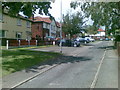
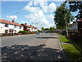
1
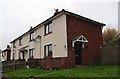
Houses on Merith Avenue
Ordnance Survey records indicate that a benchmark was cut on the near corner of the block in 1972. See www.bench-marks.org.uk/bm113309
Image: © Luke Shaw
Taken: 16 Nov 2019
0.04 miles
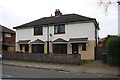
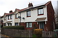
2
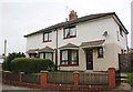
Nos. 24 and 22 Durranhill Road
Ordnance Survey records indicate that a benchmark was cut on the front corner of the right hand house in 1972 but the house has been rendered and the mark destroyed. See www.bench-marks.org.uk/bm113308 for more information.
Image: © Roger Templeman
Taken: 16 Nov 2019
0.07 miles
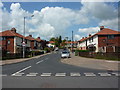
4
Florida Stores, Botcherby
A view looking to the northeast across Victoria Road towards the Florida Stores at Botcherby.
Image: © Phil Williams
Taken: 17 Feb 2007
0.09 miles
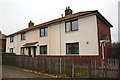
6
Nos.52 and 50 Durranhill Road
Ordnance Survey records indicate a benchmark was cut in 1972 on the side of the right hand house near its front corner which is now rendered: see www.bench-marks.org.uk/bm113314
Image: © Luke Shaw
Taken: 16 Nov 2019
0.11 miles
7
Borland Avenue houses
There is an OS benchmark Image on the side of the right hand house at its front corner
Image: © Luke Shaw
Taken: 16 Nov 2019
0.12 miles
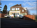
8
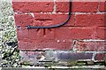
Benchmark on 99 Borland Avenue
Ordnance Survey cut mark benchmark described on the Bench Mark Database at www.bench-marks.org.uk/bm113310
Image: © Luke Shaw
Taken: 16 Nov 2019
0.12 miles
10
Holywell Crescent houses
Ordnance Survey records indicate that a benchmark was cut in 1972 on the near corner of the right hand house, but the mark may have been lost to repairs to the brickwork. There are more details at www.bench-marks.org.uk/bm113311
Image: © Luke Shaw
Taken: 16 Nov 2019
0.13 miles