IMAGES TAKEN NEAR TO
Chertsey Mount, CARLISLE, CA1 2PH
Introduction
This page details the photographs taken nearby to Chertsey Mount, CA1 2PH by members of the Geograph project.
The Geograph project started in 2005 with the aim of publishing, organising and preserving representative images for every square kilometre of Great Britain, Ireland and the Isle of Man.

There are currently over 7.5m images from over14,400 individuals and you can help contribute to the project by visiting https://www.geograph.org.uk
Image Map
Images are licensed for reuse under creativecommons.org/licenses/by-sa/2.0
Notes
- Clicking on the map will re-center to the selected point.
- The higher the marker number, the further away the image location is from the centre of the postcode.
Image Listing (121 Images Found)
Images are licensed for reuse under creativecommons.org/licenses/by-sa/2.0
Image
Details
Distance
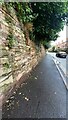
1
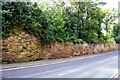
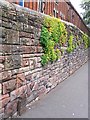
Wall on SW side of London Road
There is an Ordnance Survey benchmark Image on a stone at the base of the wall about 2m left of the black pipe secured to the wall
Image: © Luke Shaw
Taken: 24 Aug 2019
0.01 miles
2
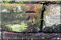
Benchmark on wall on SW side of London Road
Ordnance Survey cut mark benchmark described on the Bench Mark Database at www.bench-marks.org.uk/bm112140
Image: © Luke Shaw
Taken: 24 Aug 2019
0.02 miles
3
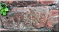
Benchmark on wall on SW side of London Road at Chertsey Mount
Appears to be an Ordnance Survey cut mark benchmark though not documented by the OS
Image: © Roger Templeman
Taken: 30 Jul 2021
0.02 miles
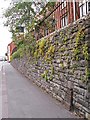
4
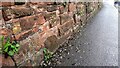
Stone wall on SW side of London Road at Chertsey Mount
There is a large benchmark Image on the stone at the left foreground of the image
Image: © Roger Templeman
Taken: 30 Jul 2021
0.02 miles
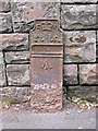
5
Wall on SW side of London Road (A6) at Chertsey Mount
Ordnance Survey records indicate that the Carlisle 1, Penrith 17 milestone was located here and had a benchmark levelled at 88.782 feet above Liverpool Datum cut on its top during the 1841-1844 Liverpool to Port Carlisle 1GL Survey. The surveyor's description was 'No. 467. Mark on top of the 17th milestone from Penrith ; 2.13 ft. above surface'
Image: © Roger Templeman
Taken: 30 Jul 2021
0.03 miles
6
Old GPO telephone cable marker, London Road (2)
A cast iron post once used to mark the location of underground telephone cables. For more detail, see Image .
Located on London Road (A6) below Summer Hill.
The junction with Trevor Street can be seen at end of this wall - there is an identical post there http://www.geograph.org.uk/photo/5222637 . Two more examples spotted on London Road at Harraby http://www.geograph.org.uk/photo/5222640 & http://www.geograph.org.uk/photo/5222642 .
Image: © Rose and Trev Clough
Taken: 11 Aug 2015
0.03 miles
7
Old GPO telephone cable marker (2), close up
For location, see Image .
At the top of the cast iron post is a crown and the initials ER - pretty sure this dates it to the reign of Edward VII (1901-1910).
Originally there would have been numbers attached showing the distance in feet and inches to a buried telephone cable or junction.
The arrow symbol was an official identifier of government property.
At the time this was installed much of the telephone network in the UK, including all trunk lines, was run by the General Post Office http://www.britishtelephones.com/histuk.htm . Later cable markers (made of concrete) had 'GPO' stamped upon them - see Image .
Image: © Rose and Trev Clough
Taken: 11 Aug 2015
0.03 miles
8
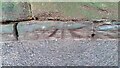
Benchmark on stone in wall at pavement level on SW side of London Road
Ordnance Survey pivot benchmark not mentioned in OS records
Image: © Roger Templeman
Taken: 12 Jan 2022
0.03 miles
9
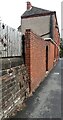
Old GPO telephone cable marker, London Road (1)
A rusty cast iron post from the Edwardian era, located near the junction of London Road (A6) and Trevor Street. Used to mark the location of underground telephone cables or joints.
For more detail, see photo of an identical post about 35m along the street Image
Two more of these markers can be seen further out of town, on London Road at Harraby http://www.geograph.org.uk/photo/5222640 & http://www.geograph.org.uk/photo/5222642.
UPDATE : This marker post has now been removed. It was present in Google Street View images in March 2019, but by September 2020 the post had gone, leaving just a dark mark on the wall behind where it was - see https://goo.gl/maps/TrLBLC9vjnRvEv9s9 .
Image: © Rose and Trev Clough
Taken: 11 Aug 2015
0.05 miles
10
Walls on NE side of London Road NW of #129
There are two benchmarks Image on the coping stones of the stone wall at the left hand side of the image
Image: © Roger Templeman
Taken: 30 Jul 2021
0.06 miles