IMAGES TAKEN NEAR TO
London Road Terrace, CARLISLE, CA1 2PF
Introduction
This page details the photographs taken nearby to London Road Terrace, CA1 2PF by members of the Geograph project.
The Geograph project started in 2005 with the aim of publishing, organising and preserving representative images for every square kilometre of Great Britain, Ireland and the Isle of Man.

There are currently over 7.5m images from over14,400 individuals and you can help contribute to the project by visiting https://www.geograph.org.uk
Image Map
Images are licensed for reuse under creativecommons.org/licenses/by-sa/2.0
Notes
- Clicking on the map will re-center to the selected point.
- The higher the marker number, the further away the image location is from the centre of the postcode.
Image Listing (133 Images Found)
Images are licensed for reuse under creativecommons.org/licenses/by-sa/2.0
Image
Details
Distance
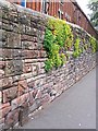
1
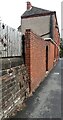
Walls on NE side of London Road NW of #129
There are two benchmarks Image on the coping stones of the stone wall at the left hand side of the image
Image: © Roger Templeman
Taken: 30 Jul 2021
0.02 miles
2
Parapet of railway tunnel and #129 London Road
Ordnance Survey documents indicate that a benchmark was levelled at 69.808 feet above Liverpool Datum on the back of the bridge 4.54 feet above rail level during the 1841-1844 Liverpool to Port Carlisle 1GL Survey. See www.bench-marks.org.uk/bm38812
Image: © Roger Templeman
Taken: 30 Jul 2021
0.02 miles
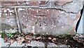
3
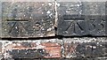
Two benchmarks on top of wall on NE side of London Road
These marks appear to be Ordnance Survey cut mark benchmarks, and shown on 1888-1913 Map as levelled at 88.8 feet above Liverpool Datum
Image: © Roger Templeman
Taken: 30 Jul 2021
0.02 miles
4
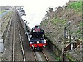
Flying Scotsman at London Road, Carlisle
The northern end of the Settle to Carlisle railway had been closed since February 2016, due to a major landslip near Armathwaite (location NY4949 http://www.geograph.org.uk/photo/5170658 ). After months of complex engineering work, this was the first day that train services through to Carlisle were resumed.
To celebrate the reopening of the line, Flying Scotsman was chartered by the Keighley and Worth Valley Railway http://kwvr.co.uk/ for a special return trip from Oxenhope.
For more information, see BBC News http://www.bbc.co.uk/news/uk-england-39447835 .
Photo taken from London Road bridge. Raised track on the left is beside the former London Road Goods Station http://www.geograph.org.uk/photo/2530114 .
Image: © Rose and Trev Clough
Taken: 31 Mar 2017
0.03 miles
5
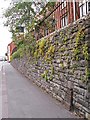
Old GPO telephone cable marker, London Road (1)
A rusty cast iron post from the Edwardian era, located near the junction of London Road (A6) and Trevor Street. Used to mark the location of underground telephone cables or joints.
For more detail, see photo of an identical post about 35m along the street Image
Two more of these markers can be seen further out of town, on London Road at Harraby http://www.geograph.org.uk/photo/5222640 & http://www.geograph.org.uk/photo/5222642.
UPDATE : This marker post has now been removed. It was present in Google Street View images in March 2019, but by September 2020 the post had gone, leaving just a dark mark on the wall behind where it was - see https://goo.gl/maps/TrLBLC9vjnRvEv9s9 .
Image: © Rose and Trev Clough
Taken: 11 Aug 2015
0.03 miles
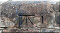
6
Benchmark on railway bridge NEC2/169 on NW side of Tyne Street
Ordnance Survey cut mark benchmark at base of the north end of the parapet of the London Road tunnel next to #120 London Road
Image: © Roger Templeman
Taken: 21 Oct 2021
0.03 miles
7
Benchmark on coping stone on wall on NE side of London Road NW of railway tunnel
Appears to be an Ordnance Survey cut mark benchmark although not described in their documents
Image: © Roger Templeman
Taken: 30 Jul 2021
0.04 miles
8
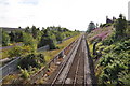
Railway at Carlisle
The railway running out towards the south.
Image: © Ashley Dace
Taken: 26 Jul 2011
0.04 miles
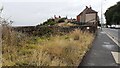
9
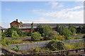
Former Fertiliser Depot
A look at the ex rail served depot that is now disused.
Image: © Ashley Dace
Taken: 26 Jul 2011
0.04 miles
10
Old GPO telephone cable marker, London Road (2)
A cast iron post once used to mark the location of underground telephone cables. For more detail, see Image .
Located on London Road (A6) below Summer Hill.
The junction with Trevor Street can be seen at end of this wall - there is an identical post there http://www.geograph.org.uk/photo/5222637 . Two more examples spotted on London Road at Harraby http://www.geograph.org.uk/photo/5222640 & http://www.geograph.org.uk/photo/5222642 .
Image: © Rose and Trev Clough
Taken: 11 Aug 2015
0.04 miles