IMAGES TAKEN NEAR TO
London Road, CARLISLE, CA1 2PE
Introduction
This page details the photographs taken nearby to London Road, CA1 2PE by members of the Geograph project.
The Geograph project started in 2005 with the aim of publishing, organising and preserving representative images for every square kilometre of Great Britain, Ireland and the Isle of Man.

There are currently over 7.5m images from over14,400 individuals and you can help contribute to the project by visiting https://www.geograph.org.uk
Image Map
Images are licensed for reuse under creativecommons.org/licenses/by-sa/2.0
Notes
- Clicking on the map will re-center to the selected point.
- The higher the marker number, the further away the image location is from the centre of the postcode.
Image Listing (152 Images Found)
Images are licensed for reuse under creativecommons.org/licenses/by-sa/2.0
Image
Details
Distance
1
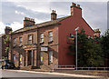
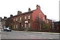
Railway Inn, London Road, Carlisle - September 2016
Opened in 1837 as the Railway Hotel, it was built to serve the London Road Station of the Newcastle and Carlisle Railway which was just across the road. One of the first pubs acquired by the Government in July 1916 under the "State Management" scheme, it returned to private ownership circa 1973. Closed as a pub since 2005, the Grade II listed red Cumbrian sandstone building has expired planning permission for conversion to retail use on the ground floor and four apartments above.
Information on the history of the pub from Gordon Edgar at: https://www.flickr.com/photos/12a_kingmoor_klickr/9759003555
Photograph for record only - I have no connection with any parties involved in the sale of these premises and cannot advise on their products or services.
Image: © The Carlisle Kid
Taken: 12 Sep 2016
0.00 miles
2

#120 London Road at junction with Tyne Street
There is an Ordnance Survey cut mark benchmark Image at the base of the bridge parapet left of the metal gate and below the bridge identification sign
Image: © Roger Templeman
Taken: 21 Oct 2021
0.01 miles
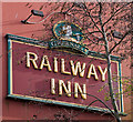
3
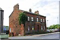
Railway Inn on SW side of London Road
Ordnance Survey records indicate that a benchmark levelled at 23.368m above Newlyn Datum was verified in 1972 on a lavatory then present built on the left hand face of the inn
Image: © Luke Shaw
Taken: 24 Aug 2019
0.01 miles
4
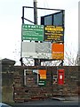
Signs for Watt's Yard, London Road
For location and further information, see Image .
Image: © Rose and Trev Clough
Taken: 29 Nov 2007
0.01 miles
5

Railway Inn, London Road, Carlisle - September 2016 (2)
A view of the back of these premises - see also: Image] .
Image: © The Carlisle Kid
Taken: 15 Sep 2016
0.01 miles
6

Railway Inn, London Road, Carlisle - September 2016 (3)
Notice above the overgrown car park.
See also: Image] .
Image: © The Carlisle Kid
Taken: 15 Sep 2016
0.01 miles
7
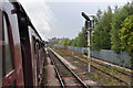
Old Sidings
Steaming into Carlisle some old siding still waiting to be reused or ripped up to the right.
Image: © Ashley Dace
Taken: 9 Oct 2010
0.01 miles
8
The Railway Inn
Opened in 1837 as the Railway Hotel, it was built to serve the London Road Station of the Newcastle and Carlisle Railway http://en.wikipedia.org/wiki/Carlisle_London_Road_railway_station , which was just across the road.
More information (and photo taken 2002) at Images of England http://www.imagesofengland.org.uk/Details/Default.aspx?id=386783&mode=adv .
Closed as a pub since 2005, the building has planning permission for conversion to retail use on the ground floor and apartments above.
Image: © Rose and Trev Clough
Taken: 9 Apr 2010
0.02 miles
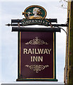
9
Railway Inn, London Road, Carlisle - March 2017 (1)
Despite the derelict condition of the premises (see: Image] ), the pub sign still hangs on the gable end.
Image: © The Carlisle Kid
Taken: 8 Mar 2017
0.02 miles
10
Railway Inn, London Road, Carlisle - March 2017 (2)
Image: © The Carlisle Kid
Taken: 8 Mar 2017
0.02 miles