IMAGES TAKEN NEAR TO
London Road Retail Park, London Road, CARLISLE, CA1 2PD
Introduction
This page details the photographs taken nearby to London Road Retail Park, London Road, CA1 2PD by members of the Geograph project.
The Geograph project started in 2005 with the aim of publishing, organising and preserving representative images for every square kilometre of Great Britain, Ireland and the Isle of Man.

There are currently over 7.5m images from over14,400 individuals and you can help contribute to the project by visiting https://www.geograph.org.uk
Image Map
Images are licensed for reuse under creativecommons.org/licenses/by-sa/2.0
Notes
- Clicking on the map will re-center to the selected point.
- The higher the marker number, the further away the image location is from the centre of the postcode.
Image Listing (81 Images Found)
Images are licensed for reuse under creativecommons.org/licenses/by-sa/2.0
Image
Details
Distance
1
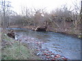
Storm damage on the River Petteril
A view looking east showing damage to the bank of the River Petteril due to recent storms.
Image: © Phil Williams
Taken: 11 Feb 2007
0.02 miles
2

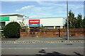
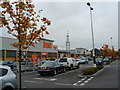
Units at London Road Retail Park
Pets at Home, Laura Ashley Home and Maplin, which was having a closing-down sale.
Image: © Rose and Trev Clough
Taken: 11 Mar 2018
0.02 miles
3

Maplin store, Carlisle
One of a chain of electronics retail stores in the UK. Sadly, Maplin went into administration in February 2018, and all of its operations had been closed down by June of that year (see Wikipedia article https://en.wikipedia.org/wiki/Maplin_(retailer) ).
Image: © Rose and Trev Clough
Taken: 11 Mar 2018
0.03 miles
4
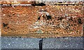
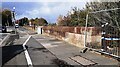
NE parapet of Harraby Bridge taking A6 over River Petteril
There is an Ordnance Survey benchmark Image on the stone at the base of the parapet between the lamppost and its shadow
Image: © Luke Shaw
Taken: 24 Aug 2019
0.05 miles
5
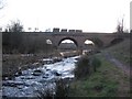
River Petteril at Harraby Bridge
A view looking to the southwest along the River Petteril towards Harraby Bridge.
Image: © Phil Williams
Taken: 11 Feb 2007
0.06 miles
6
Benchmark on NE parapet of Harraby Bridge
Ordnance Survey cut mark benchmark described on the Bench Mark Database at www.bench-marks.org.uk/bm112142
Image: © Luke Shaw
Taken: 24 Aug 2019
0.06 miles
8
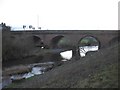
Harraby Bridge
A view looking to the southwest across the River Retteril towards Harraby Bridge.
Image: © Phil Williams
Taken: 11 Feb 2007
0.06 miles
9
Northeast parapet of Harraby Bridge which takes A6 over River Petteril
Ordnance Survey documents indicate that a benchmark was levelled at 87.062 feet above Liverpool Datum on the near end of the parapet during the 1841-1844 Liverpool to Port Carlisle 1GL Survey. The surveyor's description was 'No. 466. Bolt in South-east pier of bridge, over River Petterill ; 3.28 ft. above pathway'
Image: © Roger Templeman
Taken: 1 Nov 2022
0.06 miles
10
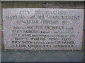
Inscription on Harraby Bridge
A view of the plaque on the parapet of Harraby Bridge.
Image: © Phil Williams
Taken: 11 Feb 2007
0.06 miles