IMAGES TAKEN NEAR TO
Bowman Street, CARLISLE, CA1 2HD
Introduction
This page details the photographs taken nearby to Bowman Street, CA1 2HD by members of the Geograph project.
The Geograph project started in 2005 with the aim of publishing, organising and preserving representative images for every square kilometre of Great Britain, Ireland and the Isle of Man.

There are currently over 7.5m images from over14,400 individuals and you can help contribute to the project by visiting https://www.geograph.org.uk
Image Map
Images are licensed for reuse under creativecommons.org/licenses/by-sa/2.0
Notes
- Clicking on the map will re-center to the selected point.
- The higher the marker number, the further away the image location is from the centre of the postcode.
Image Listing (172 Images Found)
Images are licensed for reuse under creativecommons.org/licenses/by-sa/2.0
Image
Details
Distance
1
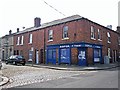
RSPCA Clinic, Close Street
Provides subsidised veterinary treatment for pets whose owners are on benefits https://www.rspca.org.uk/local/cumbria-north-and-east-branch/aboutus/contactus .
Image: © Rose and Trev Clough
Taken: 12 May 2017
0.01 miles
2
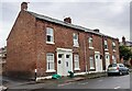
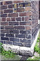
Nos. 20,18,16 and 14A Close Street
There is an Ordnance Survey benchmark Image on the left hand end of the white skirt of the nearest house
Image: © Roger Templeman
Taken: 30 Jul 2021
0.02 miles
3
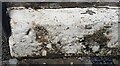
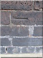
Benchmark on #20 Close Street
Ordnance Survey pivot benchmark described on the Bench Mark Database at www.bench-marks.org.uk/bm74949
Image: © Roger Templeman
Taken: 30 Jul 2021
0.02 miles
4
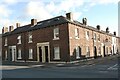
No. 16 Fusehill Street at Close Street junction
There is an Ordnance Survey benchmark Image on the corner, left hand face, of the house at the junction
Image: © Luke Shaw
Taken: 8 Aug 2019
0.03 miles
5
Benchmark on #16 Fusehill Street
Ordnance Survey cut mark benchmark described on the Bench Mark Database at http://www.bench-marks.org.uk/bm38339
Image: © Roger Templeman
Taken: 18 Jun 2011
0.04 miles
6
Ordnance Survey Cut Mark
This OS cut mark can be found at the junction of Fusehill Street and Close Street. It marks a point 17.861m above mean sea level.
Image: © Adrian Dust
Taken: 11 Apr 2016
0.04 miles
7

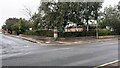
Fusehill Medical Centre
Located at the junction of Fusehill Street and Grey Road. The medical centre is operated by NHS Cumbria, and is a 5-partner practice. It opened in 2005.
Image: © Richard Dorrell
Taken: 25 Jul 2011
0.04 miles
8
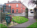
Frog litter bin
In the Fusehill Street play area. The gate is on Grey Street, Bowman Street is across the road.
The frog has a notice stuck on its leg - see Image .
Image: © Rose and Trev Clough
Taken: 19 Oct 2017
0.04 miles
9
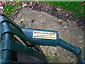
'No Household Waste' in this litter bin
Seen on a bin in the Fusehill Street play area Image .
The notice says 'It is an offence to place Household Waste into a Litter Bin'.
Well, I never knew that.
Image: © Rose and Trev Clough
Taken: 19 Oct 2017
0.04 miles
10
Well Pharmacy and Fusehill Medical Centre at Fusehill Street / Grey Street junction
There is an Ordnance Survey benchmark Image on the wall pier at the corner on its right hand face
Image: © Roger Templeman
Taken: 30 Jul 2021
0.05 miles