IMAGES TAKEN NEAR TO
Rufus Road, CARLISLE, CA1 2GU
Introduction
This page details the photographs taken nearby to Rufus Road, CA1 2GU by members of the Geograph project.
The Geograph project started in 2005 with the aim of publishing, organising and preserving representative images for every square kilometre of Great Britain, Ireland and the Isle of Man.

There are currently over 7.5m images from over14,400 individuals and you can help contribute to the project by visiting https://www.geograph.org.uk
Image Map
Images are licensed for reuse under creativecommons.org/licenses/by-sa/2.0
Notes
- Clicking on the map will re-center to the selected point.
- The higher the marker number, the further away the image location is from the centre of the postcode.
Image Listing (25 Images Found)
Images are licensed for reuse under creativecommons.org/licenses/by-sa/2.0
Image
Details
Distance
1
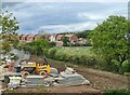
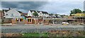
Housing development near Scotby Bridge
Image: © Chris Morgan
Taken: 22 May 2021
0.06 miles
2
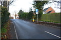
Looking NE along Durranhill Road
Ordnance Survey records indicate that in 1972 there was a benchmark on a wall on the right hand side of the road. I suspect the mark has been lost to road widening and building of new housing. See www.bench-marks.org.uk/bm113441
Image: © Luke Shaw
Taken: 18 Nov 2019
0.09 miles
4

Rails to Carlisle
This is the Newcastle - Carlisle railway west of Scotby where it passes under the M6 northbound
Image: © John Firth
Taken: 9 May 2011
0.13 miles

6

Road junction
Of Durranhill Road, Park Road and Montgomery Road
Image: © Alexander P Kapp
Taken: 16 Jun 2011
0.16 miles
7
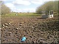
Former landfill site (Duranhill South Sidings)
Situated between the Newcastle-Carlisle and Settle-Carlisle railways, accessed by a track Image . Lorries on the M6 are just visible in the distance.
This bit of land was previously used for railway sidings then waste disposal, now restored for animal grazing.
See also Image .
Image: © Rose and Trev Clough
Taken: 31 Mar 2017
0.21 miles
8

City of Carlisle : The M6 Motorway
Looking north along the M6 Motorway.
Image: © Lewis Clarke
Taken: 22 Apr 2016
0.21 miles

10

Power line upgrade in progress
Part of a £30 million project by National Grid, to repair steelwork and replace wires, on an electricity transmission line which runs across Cumbria and Lancashire http://www.nationalgrid.com/uk/Media+Centre/PressReleases/2013/National+Grid+starts+second+phase+of+%a330m+project+to+secure+energy+supplies+06.08.13.htm .
Trackways have been laid in the field to facilitate access. Where the line crosses roads, railways, rivers etc, scaffolding is erected with safety netting strung across, as seen here on Park Road, Scotby.
Image: © Rose and Trev Clough
Taken: 18 Sep 2013
0.22 miles