IMAGES TAKEN NEAR TO
Woodrouffe Terrace, CARLISLE, CA1 2EH
Introduction
This page details the photographs taken nearby to Woodrouffe Terrace, CA1 2EH by members of the Geograph project.
The Geograph project started in 2005 with the aim of publishing, organising and preserving representative images for every square kilometre of Great Britain, Ireland and the Isle of Man.

There are currently over 7.5m images from over14,400 individuals and you can help contribute to the project by visiting https://www.geograph.org.uk
Image Map
Images are licensed for reuse under creativecommons.org/licenses/by-sa/2.0
Notes
- Clicking on the map will re-center to the selected point.
- The higher the marker number, the further away the image location is from the centre of the postcode.
Image Listing (207 Images Found)
Images are licensed for reuse under creativecommons.org/licenses/by-sa/2.0
Image
Details
Distance
1
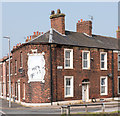
The White Ox - September 2016 (1)
The former White Ox pub, built between 1849 and 1852, it was acquired by the State Management Scheme in August 1916 and closed in 1919. The property is now a private dwelling.
Image: © The Carlisle Kid
Taken: 15 Sep 2016
0.02 miles
2
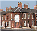
The White Ox - September 2016 (2)
Entrance to the pub was on the left and evidence of newer brickwork covering-up the old pub windows can still be seen.
For the history of this building, see: Image] .
Image: © The Carlisle Kid
Taken: 15 Sep 2016
0.02 miles
3
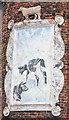
The White Ox - September 2016 (3)
The faded mural is not original, although the base and the plaster ox above do date from the former pub's Victorian era.
For the story of this building, see: Image] .
Image: © The Carlisle Kid
Taken: 13 Sep 2016
0.02 miles
4
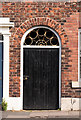
The White Ox - September 2016 (4)
Entrance from St Nicholas Street - a plan of 1879 suggests this may have given access to an area between the pub and its kitchen, although all the dwellings in the street have a similar passage-way.
For the history of this building, see: Image] .
Image: © The Carlisle Kid
Taken: 15 Sep 2016
0.02 miles
5
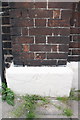
Benchmark on #11 Woodroufe Terrace
Ordnance Survey pivot benchmark described on the Bench Mark Database at http://www.bench-marks.org.uk/bm38775
Image: © Roger Templeman
Taken: 18 Jun 2011
0.02 miles
6
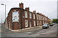
Houses on Woodroufe Terrace
#11 at junction with St Nicholas Street has large cow mural on south face
Image: © Roger Templeman
Taken: 18 Jun 2011
0.02 miles
7
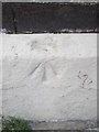
Ordnance Survey Pivot
This OS pivot can be found on No11 Woodroufe Terrace. It marks a point 18.94m above mean sea level.
Image: © Adrian Dust
Taken: 11 Apr 2016
0.02 miles
8
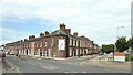
The former White Ox Inn
At the corner of Woodrouffe Terrace and St Nicholas Street, only the large faded sign on the corner indicates its original use
Image: © Kevin Waterhouse
Taken: 22 Aug 2023
0.02 miles
9

Oktays Fish 'n Chips - September 2016
Situated on St Nicholas Street, the frontage looks unaltered and suggests some form of commercial premises may have been here from the building of this street circa 1850.
Photograph is for record only - I have no connection with this business and cannot advise on its products or services.
Image: © The Carlisle Kid
Taken: 15 Sep 2016
0.04 miles
10
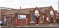
Salvation Army & Young People's Hall, Carlisle - September 2016
Situated on St Nicholas Street and dated 1931, the property is currently for sale.
Photograph is for record only - I have no connection with any parties involved in the sale of these premises and cannot advise on their products or services.
Image: © The Carlisle Kid
Taken: 13 Sep 2016
0.04 miles