IMAGES TAKEN NEAR TO
Thornthwaite, KESWICK, CA12 5SG
Introduction
This page details the photographs taken nearby to CA12 5SG by members of the Geograph project.
The Geograph project started in 2005 with the aim of publishing, organising and preserving representative images for every square kilometre of Great Britain, Ireland and the Isle of Man.

There are currently over 7.5m images from over14,400 individuals and you can help contribute to the project by visiting https://www.geograph.org.uk
Image Map
Images are licensed for reuse under creativecommons.org/licenses/by-sa/2.0
Notes
- Clicking on the map will re-center to the selected point.
- The higher the marker number, the further away the image location is from the centre of the postcode.
Image Listing (8 Images Found)
Images are licensed for reuse under creativecommons.org/licenses/by-sa/2.0
Image
Details
Distance
1
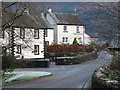
Houses in Thornthwaite
The houses are on a side road, seemingly not named, east of the main one through the village. The wooded slopes of Dodd can be seen beyond.
Image: © Trevor Littlewood
Taken: 30 Nov 2012
0.02 miles
2
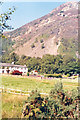
Slopes of Skiddaw massif from Thornthwaite
View NE across Derwent Valley to wooded slopes of Dodd (1,610 ft.) with Carol Side (2,448 ft.) behind: Skiddaw is off frame to the right.
Image: © Ben Brooksbank
Taken: 1 Sep 1991
0.07 miles
3
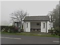
Bus shelter and telephone box, Thornthwaite
A bus shelter and public telephone box on the roadside in the centre of the small village of Thornthwaite. The bus shelter is on the southbound side of the road (for buses bound for Keswick).
Image: © Graham Robson
Taken: 4 Nov 2014
0.20 miles
4
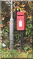
Post box, Thornthwaite
A lamp box postbox mounted on a pole beside a lamppost in the small village of Thornthwaite.
Image: © Graham Robson
Taken: 4 Nov 2014
0.21 miles
5
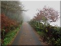
Country road north of Thornthwaite
A country road to the north of Thornthwaite. The narrow road is overshadowed by trees on the left and as a consequence the road surface is scattered with pine needles.
Image: © Graham Robson
Taken: 4 Nov 2014
0.22 miles
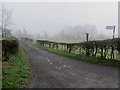
6
The approach to St Mary the Virgin church, Thornthwaite
Image: © David Purchase
Taken: 18 Mar 2013
0.23 miles
7
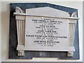
Memorial plaque, Church of St Mary, Thornthwaite
A marble memorial plaque on the north side of nave in the church.
The inscription on the memorial reads:
IN MEMORY OF
JOHN FISHER, OF JENKIN HILL
WHO DIED 22ND FEBRUARY 1976,
AE 42 YEARS.
JANE HIS WIFE,
DIED 26TH AUGUST 1840.
AE 90 YEARS
JOHN, THEIR SON,
DIED 19TH AUGUST 1817.
AE 28 YEARS
SARAH THOMPSON, THEIR DAUGHTER,
DIED 2ND MARCH 1841,
AE 55 YEARS.
ANN, THEIR DAUGHTER,
DIED 2ND JUNE 1862,
AE 75 YEARS.
Image: © Graham Robson
Taken: 4 Nov 2014
0.25 miles
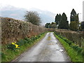
8
Lane to Thornthwaite Church
Looking along the narrow lane which leads from the village to the Church of Saint Mary, Thornthwaite.
Image: © Graham Robson
Taken: 4 Nov 2014
0.25 miles