IMAGES TAKEN NEAR TO
Thornthwaite, KESWICK, CA12 5RZ
Introduction
This page details the photographs taken nearby to CA12 5RZ by members of the Geograph project.
The Geograph project started in 2005 with the aim of publishing, organising and preserving representative images for every square kilometre of Great Britain, Ireland and the Isle of Man.

There are currently over 7.5m images from over14,400 individuals and you can help contribute to the project by visiting https://www.geograph.org.uk
Image Map
Images are licensed for reuse under creativecommons.org/licenses/by-sa/2.0
Notes
- Clicking on the map will re-center to the selected point.
- The higher the marker number, the further away the image location is from the centre of the postcode.
Image Listing (17 Images Found)
Images are licensed for reuse under creativecommons.org/licenses/by-sa/2.0
Image
Details
Distance

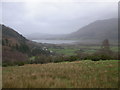
2
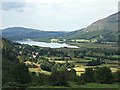
Looking over Thornthwaite
From a viewpoint on the Whinlatter Pass
Image: © Graham Hogg
Taken: 15 Jul 2019
0.11 miles
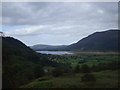
6
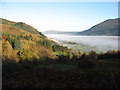
Bassenthwaite Lake under cloud
This morning a low cloud hung above the lake, with the hills in clear view.
Image: © David Purchase
Taken: 6 Nov 2011
0.18 miles
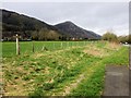
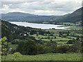
8
View from Knott Head Viewpoint
Bassenthwaite Lake can be seen - out of square - in the distance.
Image: © Peter Bond
Taken: 19 Jan 2007
0.19 miles
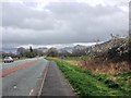
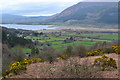
10
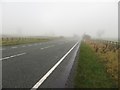
The A66 south east of Thornthwaite
Looking north west along the A66 to the south east of Thornthwaite on a misty November morning. The combination of thick mist and a busy road made crossing the carriageway slightly more precarious than it could have been.
Image: © Graham Robson
Taken: 4 Nov 2014
0.20 miles