IMAGES TAKEN NEAR TO
Portinscale, KESWICK, CA12 5RT
Introduction
This page details the photographs taken nearby to CA12 5RT by members of the Geograph project.
The Geograph project started in 2005 with the aim of publishing, organising and preserving representative images for every square kilometre of Great Britain, Ireland and the Isle of Man.

There are currently over 7.5m images from over14,400 individuals and you can help contribute to the project by visiting https://www.geograph.org.uk
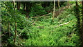
Image Map
Images are licensed for reuse under creativecommons.org/licenses/by-sa/2.0
Notes
- Clicking on the map will re-center to the selected point.
- The higher the marker number, the further away the image location is from the centre of the postcode.
Image Listing (30 Images Found)
Images are licensed for reuse under creativecommons.org/licenses/by-sa/2.0
Image
Details
Distance
1
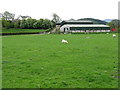
How Farm
Just north of Portinscale, off the A66 Keswick-Cockermouth road.
Image: © M J Richardson
Taken: 16 Apr 2011
0.04 miles
2
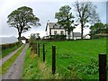
How
The hamlet of How comprises just a few houses and a farm and is accessible by a dead end road.
Image: © Mick Garratt
Taken: 25 Oct 2005
0.07 miles
3
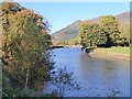
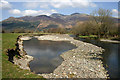
River Derwent
This stretch of the Derwent is a short 5 km reach linking Derwent Water and Bassenthwaite Lake.
The conspicuous small forested hill is Dodd Image whilst to the right and beyond is Skiddaw.
Image: © Oliver Dixon
Taken: 1 Nov 2016
0.08 miles
4
River Derwent From the Road to How
With Latrigg in the distance.
Image: © Mick Garratt
Taken: 25 Oct 2005
0.08 miles
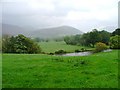
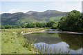
5
The River Derwent by How Farm
A view from the west bank towards Skiddaw. The river cobble deposits are the result of major flooding a few months back, and the public footpath from How Farm to Bog House is still closed due to flood damage.
Image: © Walter Baxter
Taken: 16 Apr 2010
0.09 miles
6
Former Railway Cutting
Looking in the direction of Cockermouth.
Image: © Peter Trimming
Taken: 6 Jul 2015
0.10 miles
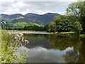
7
River Derwent near How Farm
Looking downstream with Skiddaw in the background.
Image: © Bill Boaden
Taken: 22 Jun 2019
0.11 miles
8
On The Allerdale Ramble
A view of Skiddaw from beside the River Derwent on the Allerdale Ramble route. A tranquil setting, a short walk from Portinscale.
Image: © James T M Towill
Taken: 6 Aug 2016
0.11 miles
9
Former Railway Cutting
Looking in the direction of Keswick.
Image: © Peter Trimming
Taken: 6 Jul 2015
0.11 miles
10

Pow Beck crossing the through the former railway embankment
Pow Beck flowing though a gap in the embankment of the former Cockermouth, Keswick and Penrith Railway. The bridge which once sat on the abutments carrying trains across the stream is missing, as is a footbridge which carried a right of way across the stream. The path has been rerouted via a bridge further downstream (from which I am took this photo) and provides a more direct route across the grass field.
Image: © Graham Robson
Taken: 4 Nov 2014
0.11 miles