IMAGES TAKEN NEAR TO
Park Holme, KESWICK, CA12 5PN
Introduction
This page details the photographs taken nearby to Park Holme, CA12 5PN by members of the Geograph project.
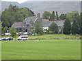
The Geograph project started in 2005 with the aim of publishing, organising and preserving representative images for every square kilometre of Great Britain, Ireland and the Isle of Man.

There are currently over 7.5m images from over14,400 individuals and you can help contribute to the project by visiting https://www.geograph.org.uk
Image Map
Images are licensed for reuse under creativecommons.org/licenses/by-sa/2.0
Notes
- Clicking on the map will re-center to the selected point.
- The higher the marker number, the further away the image location is from the centre of the postcode.
Image Listing (95 Images Found)
Images are licensed for reuse under creativecommons.org/licenses/by-sa/2.0
Image
Details
Distance
1
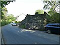
Old railway bridge abutment, Brundholme Road, Keswick
The Cockermouth, Keswick and Penrith Railway opened in 1864 and this section of it was closed in 1966.
Image: © Stephen Craven
Taken: 17 Sep 2020
0.03 miles
2
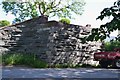
Old railway bridge abutment, Keswick
The remains of the former Cockermouth, Keswick and Penrith railway line at Brundholme Road. The line closed west of Keswick in 1966 and between Keswick and Penrith in 1972 - see https://en.wikipedia.org/wiki/Cockermouth,_Keswick_and_Penrith_Railway.
Image: © Jim Barton
Taken: 19 Jun 2019
0.03 miles
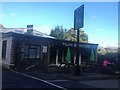
3
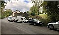
Brundholme Road
The old railway line crossed Brundholme Road at this point and the remains of the railway bridge can be seen behind the parked vehicles.
Image: © Chris Thomas-Atkin
Taken: 11 Oct 2020
0.03 miles
4
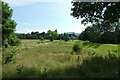
Grassland beside Brundholme Road
Looking across grassland behind the hospital.
Image: © DS Pugh
Taken: 19 Jul 2021
0.05 miles
6
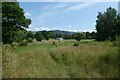
Land behind the hospital
Looking across fields beside Brundholme Road.
Image: © DS Pugh
Taken: 19 Jul 2021
0.05 miles
7
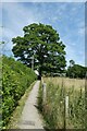
Path beside Brundholme Road
Looking along a path with Brundholme Road on the other side of the hedge.
Image: © DS Pugh
Taken: 19 Jul 2021
0.05 miles
8
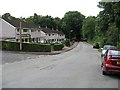
Brundholme Road, Keswick
A favourite parking spot for walkers setting out for Skiddaw.
Image: © Roger Smith
Taken: 1 Sep 2008
0.06 miles
9
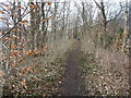
Former railway route, heading east to Keswick Station
Not mapped as a public footpath, but well-used.
Image: © Christine Johnstone
Taken: 25 Mar 2018
0.07 miles