IMAGES TAKEN NEAR TO
Bridge Terrace, KESWICK, CA12 5NU
Introduction
This page details the photographs taken nearby to Bridge Terrace, CA12 5NU by members of the Geograph project.
The Geograph project started in 2005 with the aim of publishing, organising and preserving representative images for every square kilometre of Great Britain, Ireland and the Isle of Man.

There are currently over 7.5m images from over14,400 individuals and you can help contribute to the project by visiting https://www.geograph.org.uk
Image Map
Images are licensed for reuse under creativecommons.org/licenses/by-sa/2.0
Notes
- Clicking on the map will re-center to the selected point.
- The higher the marker number, the further away the image location is from the centre of the postcode.
Image Listing (389 Images Found)
Images are licensed for reuse under creativecommons.org/licenses/by-sa/2.0
Image
Details
Distance

2
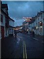
Main Street, Keswick.
Christmas lights on Main Street, seen in gathering dusk.
Image: © Colin Pyle
Taken: Unknown
0.02 miles
3
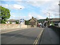
Greta Bridge, Keswick
Greta Bridge takes the A5271 road over the River Greta on the northern approach to Keswick town centre.
This is the route of The Cumbria Way long distance path (next photograph Image).
Image: © Adrian Taylor
Taken: 19 Sep 2015
0.03 miles
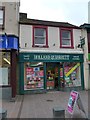
4
![Keswick houses [1]](https://s1.geograph.org.uk/geophotos/06/21/60/6216081_5fdee157_120x120.jpg)
Keswick houses [1]
Numbers 123 and 125 Main Street are a pair of identical houses. Interestingly one has a door lintel with the date 1707 whilst the other is dated 1736. Listed, grade II, with details at: https://historicengland.org.uk/listing/the-list/list-entry/1137386
Image: © Michael Dibb
Taken: 20 Jun 2019
0.03 miles
5
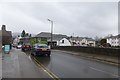
Main Street crossing the River
Main Street in Keswick crossing the River Greta.
Image: © DS Pugh
Taken: 26 Mar 2016
0.03 miles
6
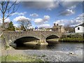
Greta Bridge, Keswick
The River Greta flows through the town of Keswick. It is a tributary of the River Derwent. The source of the river is to be found near to Threlkeld.
The bridge, which takes traffic into (and out of) the centre of Keswick, was rebuilt in 1926.
Image: © David Dixon
Taken: 12 Apr 2014
0.03 miles
8
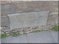
Old Bridge Marker by the A5271, Greta Bridge. Morpeth
Bridge Marker by the A5271, in parish of Keswick (Allerdale District), Greta Bridge, River Greta, set on bridge parapet, West side of road.
Surveyed
Milestone Society National ID: CU_KESW01br.
Image: © Milestone Society
Taken: Unknown
0.04 miles
9
![Keswick buildings [6]](https://s2.geograph.org.uk/geophotos/06/21/70/6217018_190cc34f_120x120.jpg)
Keswick buildings [6]
These buildings were formerly part of Keswick School and have been redeveloped as the Rawnsley Centre.
Image: © Michael Dibb
Taken: 20 Jun 2019
0.04 miles
10
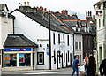
Main Street, Keswick
At its junction with Tithebarn Street.
Image: © Brian Clift
Taken: 17 Apr 2010
0.04 miles