IMAGES TAKEN NEAR TO
Threlkeld, KESWICK, CA12 4SX
Introduction
This page details the photographs taken nearby to CA12 4SX by members of the Geograph project.
The Geograph project started in 2005 with the aim of publishing, organising and preserving representative images for every square kilometre of Great Britain, Ireland and the Isle of Man.

There are currently over 7.5m images from over14,400 individuals and you can help contribute to the project by visiting https://www.geograph.org.uk
Image Map
Images are licensed for reuse under creativecommons.org/licenses/by-sa/2.0
Notes
- Clicking on the map will re-center to the selected point.
- The higher the marker number, the further away the image location is from the centre of the postcode.
Image Listing (15 Images Found)
Images are licensed for reuse under creativecommons.org/licenses/by-sa/2.0
Image
Details
Distance
1
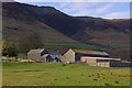
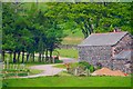
Threlkeld Hall
The original manor for the area, now a farm. Blencathra behind.
Image: © Ian Capper
Taken: 10 Apr 2008
0.02 miles
2
Threlkeld Hall
The original manor for the area, now a farm. On the left of the photo in the background can be seen the clubhouse for Keswick Golf Club.
Image: © Ian Capper
Taken: 9 Apr 2008
0.02 miles
4
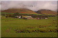
Threlkeld Hall
Looking down onto the farm from Doddick Fell where the farmer has just muck spread the fields.
Image: © Mick Garratt
Taken: 31 Dec 2009
0.04 miles
5
Threlkeld Hall
The original manor for the area, now a farm. Hall's Fell on Blencathra, visible behind, is named after the hall.
Image: © Ian Capper
Taken: 9 Apr 2008
0.08 miles
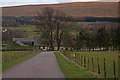
7
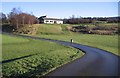
Keswick golf club.
A sweeping drive up to the clubhouse.
Image: © John Holmes
Taken: 24 Dec 2005
0.17 miles
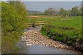
8
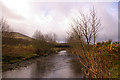
Bridge over River Glenderamackin
This bridge leads to Keswick Golf Club.
Image: © Ian Capper
Taken: 9 Apr 2008
0.18 miles