IMAGES TAKEN NEAR TO
Threlkeld, KESWICK, CA12 4ST
Introduction
This page details the photographs taken nearby to CA12 4ST by members of the Geograph project.
The Geograph project started in 2005 with the aim of publishing, organising and preserving representative images for every square kilometre of Great Britain, Ireland and the Isle of Man.

There are currently over 7.5m images from over14,400 individuals and you can help contribute to the project by visiting https://www.geograph.org.uk
Image Map
Images are licensed for reuse under creativecommons.org/licenses/by-sa/2.0
Notes
- Clicking on the map will re-center to the selected point.
- The higher the marker number, the further away the image location is from the centre of the postcode.
Image Listing (89 Images Found)
Images are licensed for reuse under creativecommons.org/licenses/by-sa/2.0
Image
Details
Distance
1
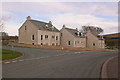
New housing
Being built (April 2008) at the east end of the village.
Image: © Ian Capper
Taken: 6 Apr 2008
0.02 miles
3
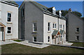
Threlkeld
Newly built houses in Threlkeld.
Image: © Peter McDermott
Taken: 18 Apr 2009
0.03 miles
4
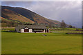
Thelkeld Sports Pavilion
Built in 2002 and used by the Threlkeld Cricket Club - one of the more attractive settings for the game (although it would be even better without the A66 next door)!
Image: © Ian Capper
Taken: 9 Apr 2008
0.04 miles
5
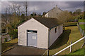
Threlkeld Telephone Exchange
Much bigger than the former exchange (see Image).
Image: © Ian Capper
Taken: 10 Apr 2008
0.05 miles
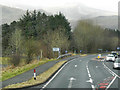
6
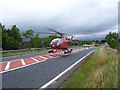
Not an everyday occurrence on the A66
Air ambulance removes casualty to hospital care much faster than an ambulance so giving the casualty a better chance of survival after an accident or road collision.
Image: © John Holmes
Taken: 29 Jul 2005
0.06 miles
7
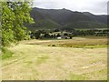
Newly Mown Hay Meadow, Threlkeld
The white marquee is on the grounds of Threlkeld Cricket Club and hosted a dance the night before. Beyond lies Blencathra with the summit, Hallsfell Top, and the two ridges, Gategill (left) and Halls (right) obvious.
Image: © Mick Garratt
Taken: 16 Jul 2005
0.06 miles
8
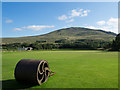
Threlkeld cricket ground
The cricket ground is close to the village but separated from it by the A66. The field is a small one - the boundary is not far from the wicket and so scores there could be high. The distant mountain is Clough Head - the northern terminus of the Helvellyn range.
Image: © Trevor Littlewood
Taken: 6 Sep 2015
0.06 miles
9

Topiary, Threlkeld
Interesting decorations on a garden hedge in the village. The telephone kiosk on the right has the honour of appearing on the village direction sign off the A66 but houses no telephone.
Image: © E Gammie
Taken: 21 Aug 2018
0.07 miles
