IMAGES TAKEN NEAR TO
Threlkeld, KESWICK, CA12 4SG
Introduction
This page details the photographs taken nearby to CA12 4SG by members of the Geograph project.
The Geograph project started in 2005 with the aim of publishing, organising and preserving representative images for every square kilometre of Great Britain, Ireland and the Isle of Man.

There are currently over 7.5m images from over14,400 individuals and you can help contribute to the project by visiting https://www.geograph.org.uk
Image Map
Images are licensed for reuse under creativecommons.org/licenses/by-sa/2.0
Notes
- Clicking on the map will re-center to the selected point.
- The higher the marker number, the further away the image location is from the centre of the postcode.
Image Listing (23 Images Found)
Images are licensed for reuse under creativecommons.org/licenses/by-sa/2.0
Image
Details
Distance
1
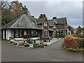
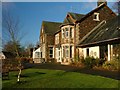
The main building at the Blencathra Centre
Image: © David Medcalf
Taken: 16 Nov 2022
0.01 miles
2
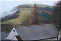
Latrigg from The Blencathra Centre
Clouds lingering Brundholme Wood on the southern slope.
Image: © Mick Garratt
Taken: 29 Dec 2007
0.01 miles
3
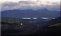
Keswick in the Gloaming
View from the Blencathra Centre. After constant rain throughout the day the finally brightened up after dusk. Derwentwater reflects the last of the daylight. Cars on the A66 have their lights on and a few lights in Keswick can just be made out. A sprinkling of snow coats the tops of the Grasmoor Fells.
Image: © Mick Garratt
Taken: 29 Dec 2007
0.03 miles
4
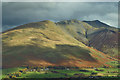
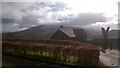
Blease Fell and the Blencathra Centre
Blease Fell is said to be the easy way up Blencathra. Starting from the Blencathra Centre, the complex of slate buildings bottom left in the photo, it is at first a seemingly relentless climb but then follows a pleasant ridge to the highest point at 868 m or 2,848 ft in old money.
The Blencathra Centre is a Field Studies Council residential centre. Originally it was a sanatorium for the treatment of tuberculosis or consumption as the disease was then known. When it opened in 1904 TB was a serious health problem, for which the recognised treatment was fresh air and clean water both of which were in abundance high on the fells. Furthermore, it had been known since the 1880s that the disease was highly contagious so another reason for the isolated location of sanatoria. We now know of course that TB is caused by the bacterium Mycobacterium tuberculosis and treatment is by antibiotics.
Coincidentally, the first annual meeting of the Cumberland Branch of the National Association for the Prevention of Consumption and other forms of Tuberculosis, which was responsible for the building of the sanatorium at Blease Fell was held in 1900. Canon Rawnsley who gifted Peace How, the subject of yesterday’s post was one of the attendees. Image]
From my blog http://www.fhithich.uk/?p=20426
Image: © Mick Garratt
Taken: 7 Nov 2018
0.03 miles
6
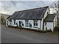
The home of the Mountain Heritage Trust
At the Blencathra Centre.
Image: © David Medcalf
Taken: 16 Nov 2022
0.03 miles
7
A building with a view
At the Blencathra Centre.
Image: © David Medcalf
Taken: 16 Nov 2022
0.03 miles
8
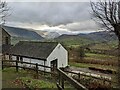
The Blencathra Centre
One of the many buildings forming part of this outdoor centre.
Image: © Mick Garratt
Taken: 29 Dec 2007
0.04 miles
9
Blencathra Centre
Built in 1898 as the Blencathra Sanatorium for Tuberculosis where the fresh air was considered an essential part of the treatment. During the 1940s/50s the number of patients declined and the hospital became a long stay home for the eldery. In 1975 after being empty for several years it became self catering holiday accommodation. Finally in 1995 it was opened by David Bellamy as a Field Centre.
Image: © Mick Garratt
Taken: 1 Jan 2006
0.05 miles
10
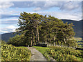
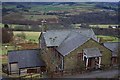
Track west of Threlkeld
The minor road which runs westwards from Threlkeld becomes a track by this small plantation - the track continues northwards between Lonscale Fell and Blease Fell.
Image: © William Starkey
Taken: 19 Aug 2014
0.06 miles