IMAGES TAKEN NEAR TO
St. Johns-in-the-Vale, KESWICK, CA12 4RR
Introduction
This page details the photographs taken nearby to CA12 4RR by members of the Geograph project.
The Geograph project started in 2005 with the aim of publishing, organising and preserving representative images for every square kilometre of Great Britain, Ireland and the Isle of Man.

There are currently over 7.5m images from over14,400 individuals and you can help contribute to the project by visiting https://www.geograph.org.uk
Image Map
Images are licensed for reuse under creativecommons.org/licenses/by-sa/2.0
Notes
- Clicking on the map will re-center to the selected point.
- The higher the marker number, the further away the image location is from the centre of the postcode.
Image Listing (24 Images Found)
Images are licensed for reuse under creativecommons.org/licenses/by-sa/2.0
Image
Details
Distance
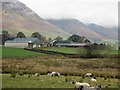
1
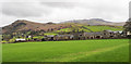
A complex of farm buildings
Buildings at Burns Farm and Low Burns Farm appear to feature in the image.
Low Rigg is the hill to the left with Bleaberry Fell higher, and more distant to the right.
Image: © Trevor Littlewood
Taken: 9 Mar 2020
0.03 miles
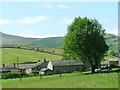
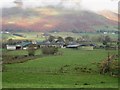
3
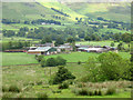
Burns Farm
A view from the slopes of Low Rigg.
Image: © Stephen Craven
Taken: 22 Jun 2011
0.03 miles
4
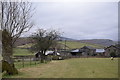
Approaching Burns Farm
Low Rigg can be seen beyond the farm buildings ahead.
Image: © Trevor Harris
Taken: 11 Feb 2017
0.05 miles
5
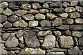
Lakeland Stone Wall Burns Farm Keswick
Image: © Peter Skynner
Taken: 7 Apr 2008
0.05 miles
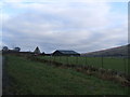
7
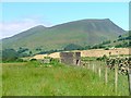
Water Authority Building ...
... and covered reservoir (?). Viewed looking north towards Lonscale Fell with Skiddaw behind and to the left.
Image: © Mick Garratt
Taken: 16 Jul 2005
0.12 miles
9
Looking across grassland towards Burns Farm
Looking across rough grassland, occupied by sheep, towards Burns Farm. The lower slopes of Blencathra can be seen in the background.
Image: © Graham Robson
Taken: 5 Nov 2013
0.17 miles
10
Grass paddocks, with Burns Farm in the distance
Looking across grassland at Hollin Root. Burns Farm is in the distance in front of the lower slopes of Blencathra.
Image: © Graham Robson
Taken: 5 Nov 2013
0.18 miles