IMAGES TAKEN NEAR TO
KESWICK, CA12 4NS
Introduction
This page details the photographs taken nearby to CA12 4NS by members of the Geograph project.
The Geograph project started in 2005 with the aim of publishing, organising and preserving representative images for every square kilometre of Great Britain, Ireland and the Isle of Man.

There are currently over 7.5m images from over14,400 individuals and you can help contribute to the project by visiting https://www.geograph.org.uk
Image Map
Images are licensed for reuse under creativecommons.org/licenses/by-sa/2.0
Notes
- Clicking on the map will re-center to the selected point.
- The higher the marker number, the further away the image location is from the centre of the postcode.
Image Listing (140 Images Found)
Images are licensed for reuse under creativecommons.org/licenses/by-sa/2.0
Image
Details
Distance
1
Greta Bank Farm
A view from Brundholme Road to the east. Older maps show the name as Gretabank; new maps show it as two words.
Image: © Stephen Craven
Taken: 21 Jun 2011
0.01 miles
2
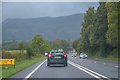
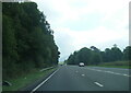
Keswick : Keswick Bypass A66
Looking along the Keswick Bypass.
Image: © Lewis Clarke
Taken: 26 Sep 2019
0.06 miles
3
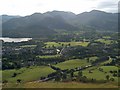
The western side of Latrigg
This looks down on, amongst other things, the A66 Keswick bypass.
Image: © Bill Boaden
Taken: 29 Aug 2007
0.08 miles
4
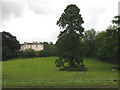
Solitary tree in the grounds of Windebrowe
An impressive tree (possibly a Wellingtonia?) seen from the public footpath to Calvert's Bridge.
Image: © Stephen Craven
Taken: 21 Jun 2011
0.16 miles
6
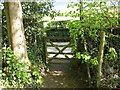
Footpath Gate, Briar Rigg
The footpath parallel to Brundholme Road runs behind the houses on Calvert Way; it ends at a wooden gate leading out on to Brundholme Road.
This is the route of The Cumbria Way long distance footpath (next photograph Image).
Image: © Adrian Taylor
Taken: 15 May 2016
0.18 miles
7
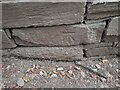
Ordnance Survey Cut Mark
This OS cut mark can be found on the NE buttress of the railway bridge. It marks a point 98.160m above mean sea level.
Image: © Adrian Dust
Taken: 14 Sep 2022
0.18 miles
8
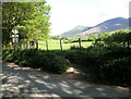
The Cumbria Way, Briar Rigg
The Cumbria Way crosses Brundholme Road and continues along a footpath on the opposite side, parallel to the road (next photograph Image).
Image: © Adrian Taylor
Taken: 15 May 2016
0.18 miles
9
![Over the bypass [2]](https://s0.geograph.org.uk/geophotos/06/21/47/6214760_f3edd322_120x120.jpg)
Over the bypass [2]
The A66 Kendal Bypass, looking east, seen from the bridge carrying Spoonygreen Lane. The lane is a public bridleway, part of the long distance Cumbria Way which runs 70 miles (112 km) from Carlisle to Ulverston.
Image: © Michael Dibb
Taken: 20 Jun 2019
0.18 miles
10
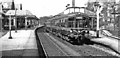
Keswick station, with new DMU, 1956
View westward, towards Cockermouth and Workington, ex-LNWR Cockermouth, Keswick & Penrith section. This was one of the earliest lines to change to DMUs; here a Derby 'Lightweight' unit is working a Workington - Penrith service. Their introduction boosted traffic considerably, but nevertheless the line was closed west of Keswick from 4/66 and to Penrith from 6/3/72 - in spite of its being the main rail route into the heart of the Lake District.
Image: © Walter Dendy, deceased
Taken: 24 Apr 1956
0.19 miles