IMAGES TAKEN NEAR TO
Latrigg Close, KESWICK, CA12 4LG
Introduction
This page details the photographs taken nearby to Latrigg Close, CA12 4LG by members of the Geograph project.
The Geograph project started in 2005 with the aim of publishing, organising and preserving representative images for every square kilometre of Great Britain, Ireland and the Isle of Man.

There are currently over 7.5m images from over14,400 individuals and you can help contribute to the project by visiting https://www.geograph.org.uk
Image Map
Images are licensed for reuse under creativecommons.org/licenses/by-sa/2.0
Notes
- Clicking on the map will re-center to the selected point.
- The higher the marker number, the further away the image location is from the centre of the postcode.
Image Listing (117 Images Found)
Images are licensed for reuse under creativecommons.org/licenses/by-sa/2.0
Image
Details
Distance
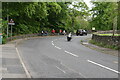
3
![Along the former railway [7]](https://s3.geograph.org.uk/geophotos/06/21/21/6212131_06e3ed92_120x120.jpg)
Along the former railway [7]
A section of the path created on the trackbed of the dismantled Cockermouth, Keswick and Penrith Railway.
A four mile long footpath was created by the Lake District National Park Authority between Threlkeld and Keswick though the Greta Gorge. Three bridges on the footpath were damaged or destroyed in the winter 2015 floods and are still (in 2019) in the process of being repaired.
The Cockermouth, Keswick and Penrith Railway was 31½ miles long with eight intermediate stations and opened in 1864. The section from Keswick to Cockermouth was closed in 1966 leaving Keswick at the end of a single line branch from Penrith which survived until 6th March, 1972.
Image: © Michael Dibb
Taken: 20 Jun 2019
0.05 miles
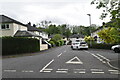
4
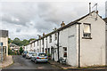
Brigham Row
19th Century terrace off Penrith Road, shown on the 1867 6 inch map simply as The Row.
Image: © Ian Capper
Taken: 24 Sep 2018
0.05 miles
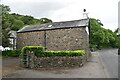
9
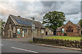
Former Brigham School
The former Brigham School on Penrith Road, with a date plaque on the building on the left of 1851. The building on the right was added in 1895. The school closed in the 1990s following the building of St Kentigern’s School in Trinity Way in 1993, now part of St Herbert's School. The buildings now house a double glazing firm.
Image: © Ian Capper
Taken: 24 Sep 2018
0.07 miles