IMAGES TAKEN NEAR TO
Penrith Road, KESWICK, CA12 4HF
Introduction
This page details the photographs taken nearby to Penrith Road, CA12 4HF by members of the Geograph project.
The Geograph project started in 2005 with the aim of publishing, organising and preserving representative images for every square kilometre of Great Britain, Ireland and the Isle of Man.

There are currently over 7.5m images from over14,400 individuals and you can help contribute to the project by visiting https://www.geograph.org.uk
Image Map
Images are licensed for reuse under creativecommons.org/licenses/by-sa/2.0
Notes
- Clicking on the map will re-center to the selected point.
- The higher the marker number, the further away the image location is from the centre of the postcode.
Image Listing (679 Images Found)
Images are licensed for reuse under creativecommons.org/licenses/by-sa/2.0
Image
Details
Distance
1
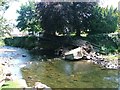
Former Footbridge Over the River Greta
Suffering from damage from the 2005 floods.
Image: © Mick Garratt
Taken: 16 Jul 2005
0.01 miles
2
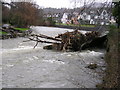
Remains of the footbridge over the river Greta
Image: © Richard Swales
Taken: 8 Jan 2005
0.01 miles
3
Footbridge over the River Greta
From memory, this sturdy tubular steel structure has replaced a precarious suspension bridge which flexed when walked across!
Image: © Andy Beecroft
Taken: 24 Jul 2007
0.01 miles
4

Goldilocks and the Three Bears
A mural inside a bus shelter, commemorating that the story of the three bears was first written in 1837 by Robert Southey, who lived at Greta Hall, Keswick. See Image for an external view.
Image: © Ian Taylor
Taken: 25 Sep 2021
0.02 miles
5

Bus shelter, Penrith Road
See Image for a view of the mural inside.
Image: © Ian Taylor
Taken: 25 Sep 2021
0.02 miles
6
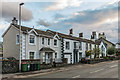
Penrith Road
Early 19th Century housing on Penrith Road, in a section of the road marked on the 1867 6 inch map as Shorley Croft.
Image: © Ian Capper
Taken: 24 Sep 2018
0.03 miles
7
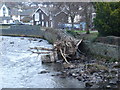
Death of a footbridge
The floods of winter 2004/5 were mostly on the news for the effects in Carlisle, but the same weather affected this area. The old Fitz Park footbridge could probably have survived the effects of just the water, as it had open fencing sides, but the impact and greater hydraulic resistance of trees sounded its death knell and flattened it into the left bank. We had paddled the river (at a fairly low level) on the day of this photograph and had noted some significant changes to the river's topography as rapids had washed out, a well-known overhanging tree had disappeared and several others threatened to fall into the river. Four years later, the river is changing more gradually, but is on its way to being more as it was. The footbridge itself has been replaced with a new one higher above the river level.
Image: © Andy Waddington
Taken: 24 Jan 2005
0.03 miles
8
![Over the river [2]](https://s3.geograph.org.uk/geophotos/06/21/81/6218143_aea69768_120x120.jpg)
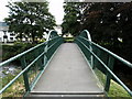
Over the river [2]
This footbridge links Penrith Road with Upper Fitz Park. Seen from the bridge carrying Station Road.
Image: © Michael Dibb
Taken: 20 Jun 2019
0.03 miles
9
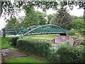
Footbridge to Fitz Park
Image: © Stephen Craven
Taken: 21 Jun 2011
0.03 miles
10
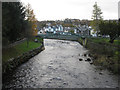
River Greta, Keswick
Looking upstream along the River Greta flowing through Keswick from the Station Street bridge over the river. The footbridge in the picture connects both sides of Fitz Park, through which the river flows, the smaller side being on the left of the photo.
Image: © Graham Robson
Taken: 7 Nov 2012
0.03 miles