IMAGES TAKEN NEAR TO
Halls Mead, KESWICK, CA12 4BE
Introduction
This page details the photographs taken nearby to Halls Mead, CA12 4BE by members of the Geograph project.
The Geograph project started in 2005 with the aim of publishing, organising and preserving representative images for every square kilometre of Great Britain, Ireland and the Isle of Man.

There are currently over 7.5m images from over14,400 individuals and you can help contribute to the project by visiting https://www.geograph.org.uk
Image Map
Images are licensed for reuse under creativecommons.org/licenses/by-sa/2.0
Notes
- Clicking on the map will re-center to the selected point.
- The higher the marker number, the further away the image location is from the centre of the postcode.
Image Listing (35 Images Found)
Images are licensed for reuse under creativecommons.org/licenses/by-sa/2.0
Image
Details
Distance
1
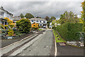
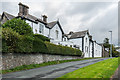
Halls Mead
c1930s housing in Halls Mead.
Image: © Ian Capper
Taken: 24 Sep 2018
0.01 miles
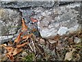
2
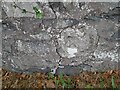
Ordnance Survey Cut Mark
This OS cut mark can be found on the wall north side of Ambleside Road. It marks a point 111.753m above mean sea level.
Image: © Adrian Dust
Taken: 14 Sep 2022
0.04 miles
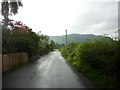
3
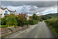
Springs Road
c1930s housing on Springs Road on what was prior to development the access track to the 19th Century Springs Farm.
Image: © Ian Capper
Taken: 24 Sep 2018
0.05 miles
4
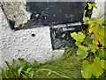
Ordnance Survey Cut Mark
This OS cut mark can be found on the south face of Castlerigg Manor on Ambleside Road. It marks a point 124.1051m above mean sea level.
Image: © Adrian Dust
Taken: 14 Sep 2022
0.06 miles
5
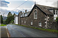
Casterigg Manor
Mid 19th Century house in Manor Brow, marked on the 1864 1:2,500 map as Castlerigg House, on the 1899 edition as Castlerigg Manor, on the 1968 edition as Castlerigg Manor Hotel (the Wikipedia article on the manor suggests it became a hotel in the 1920s) and on the 1985 edition as Castlerigg Manor Catholic Youth Centre. It has served in this later role since 1969 when it was purchased by the RC Diocese of Lancaster.
Grade II listed - see historicengland.org.uk/listing/the-list/list-entry/1327115.
Image: © Ian Capper
Taken: 24 Sep 2018
0.06 miles
8
Casterigg Manor
Mid 19th Century house in Manor Brow, marked on the 1864 1:2,500 map as Castlerigg House, on the 1899 edition as Castlerigg Manor, on the 1968 edition as Castlerigg Manor Hotel (the Wikipedia article on the manor suggests it became a hotel in the 1920s) and on the 1985 edition as Castlerigg Manor Catholic Youth Centre. It has served in this latter role since 1969 when it was purchased by the RC Diocese of Lancaster.
Grade II listed - see www.historicengland.org.uk/listing/the-list/list-entry/1327115.
Image: © Ian Capper
Taken: 24 Sep 2018
0.07 miles
9
Ordnance Survey Cut Mark
This OS cut mark can be found on the wall north side of Ambleside Road. It marks a point 99.075m above mean sea level.
Image: © Adrian Dust
Taken: 14 Sep 2022
0.08 miles
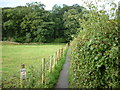
10
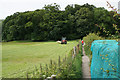
Path to Castlehead
Access to this small wooded hill from Springs Road. The netting apparently helps the Keswick Flood Alleviation Scheme, but I am not quite sure how.
Image: © Bill Boaden
Taken: 23 Jun 2019
0.09 miles